 |
Paso-Robles
is located in central California, approximately 25 miles inland from the ocean. With a more pronounced change of seasons than the coastal cities, Paso Robles has hot summers and cooler winters. Surrounded by vineyards, Paso Robles is in the heart of the central California wine country and home to 20 wineries. This small town is probably most well known as the home of the California Mid State Fair. Held once a year, people come from all over to enjoy the rides, competitions, and food and live entertainment at the fair. Other year round attractions include visiting the historic Mission San Miguel which was founded in 1797, taking a tour of the beautifully restored Victorian homes along Vine Street, or relax at one of the area's mineral hot springs. For outdoor recreation, the nearby lakes of Nacimiento, San Antonio, Santa Margarita offer numerous opportunities for world class bass fishing, swimming, boating, hiking, horseback riding, camping and more. Colorful local inns and bed and breakfasts offer a charming spot for rest and relaxation. Paso Robles is a wonderful place to visit in and of itself, or it makes a great stopping point if you are traveling between the major cities of San Francisco and Los Angeles.
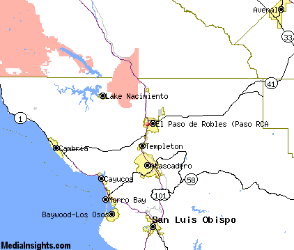
Surrounding areas: Atascadero, California (10.8 mi), Lake Nacimiento, California (13.2 mi), Cayucos, California (17.2 mi), Morro Bay, California (19.4 mi), Baywood Park, California (22.3 mi), Cambria, California (22.9 mi), Los Osos, California (22.9 mi)
|

|
Paso Robles Vacation Rentals
|

|
|
|
|
|
Paso Robles Hotels and Resorts
|
|
|
| | | Hotels & Motels |
| Adelaide Motor Inn | 1215 Ysabell Ave | Paso Robles, CA | | (805) 238-2770 | | Best Western Black Oak Motor Lodge | 1135 24TH St | Paso Robles, CA | | (805) 238-4740 | | Hampton Inn & Suites | 212 Alexa Court | Paso Robles, CA | | (805) 226-9988 | | Holiday Inn Express | 2455 Riverside Ave | Paso Robles, CA | | (805) 238-6500 | | La Bellasera Hotel & Suites | 206 Alexa Ct | Paso Robles, CA | | (805) 238-2834 | | Travelodge Paso Robles | 2701 SPG St | Paso Robles, CA | | (805) 238-0078 | | Motel 6 #1372 | 1134 Black Oak Dr | Paso Royales, CA | 1.2 mi. | (805) 239-9090 | | Best Western Colony Inn | 3600 El Camino Real | Atascadero, CA | 8.6 mi. | (805) 466-4449 | | Motel 6 #351 | 9400 El Camino Real | Atascadero, CA | 11.2 mi. | (805) 466-6701 | | Beachwalker Inn | 501 S Ocean Ave | Cayucos, CA | 17.1 mi. | (805) 995-2133 | | El Ranch Best Western | 2460 Main St | Morro Bay, CA | 19.1 mi. | (805) 772-2212 | | Motel 6 | 298 Atascadero Rd | Morro Bay, CA | 19.4 mi. | (805) 772-5641 | | Days Inn Harbor House | 1095 Main St | Morro Bay, CA | 20.0 mi. | (800) 247-5076 | | Econo Lodge | 1100 Main St | Morro Bay, CA | 20.0 mi. | (805) 772-5609 | | Bay View Lodge | 225 HBR St | Morro Bay, CA | 20.1 mi. | (805) 772-2771 | | The Inn At Morro Bay | 19 Country CLB Rd | Morro Bay, CA | 20.1 mi. | (805) 772-5651 | | Ascot Suites | 260 Morro Bay Blvd | Morro Bay, CA | 20.2 mi. | (805) 772-4437 | | Best Western San Marcos Motor Inn | 250 Pacific St | Morro Bay, CA | 20.2 mi. | (805) 772-2248 | | Blue Sail Inn | 851 Market Ave | Morro Bay, CA | 20.2 mi. | (805) 772-7132 | | Embarcadero Inn | 456 Embarcadero | Morro Bay, CA | 20.4 mi. | (805) 772-2700 | | Inn At Morro Bay | 60 State Park Rd | Morro Bay, CA | 20.8 mi. | (805) 772-5651 | | Creekside Inn | 2618 Main St | Cambria, CA | 22.2 mi. | (805) 927-4021 | | Best Western Fireside Inn | 6700 Moonstone Beach | Cambria, CA | 22.3 mi. | (805) 927-8661 | | White Water Inn | 6790 Moonstone BCH Dr | Cambria, CA | 22.3 mi. | (805) 927-1066 | | Cambria Pines Lodge | 2905 Burton Dr | Cambria, CA | 22.4 mi. | (805) 927-4200 | | Burton Drive Inn - Sylvia's | 4022 Burton Dr | Cambria, CA | 22.5 mi. | (805) 927-5125 | | Blue Heron | 1899 9TH St | Los Osos, CA | 22.9 mi. | (805) 528-1493 | | Apple Farm Inn | 2015 Monterey St | San Luis Obispo, CA | 23.3 mi. | (805) 544-1317 | | Days Inn | 2050 Garfield St | San Luis Obispo, CA | 23.3 mi. | (805) 549-9911 | | La Cuesta Motor Inn | 2074 Monterey St | San Luis Obispo, CA | 23.3 mi. | (805) 543-2777 | | Best Western Somerset Inn | 1895 Monterey St | San Luis Obispo, CA | 23.4 mi. | (805) 544-0973 | | Sands Suites & Motel | 1930 Monterey St | San Luis Obispo, CA | 23.4 mi. | (805) 544-0500 | | Super 8 Motel | 1951 Monterey St | San Luis Obispo, CA | 23.4 mi. | (805) 544-7895 | | Holiday Inn Express | 1800 Monterey St | San Luis Obispo, CA | 23.5 mi. | (805) 544-8600 | | Travelodge | 1825 Monterey St | San Luis Obispo, CA | 23.5 mi. | (805) 543-5110 | | Comfort Inn & Suites Lamplighter | 1604 Monterey St | San Luis Obispo, CA | 23.6 mi. | (805) 547-7777 | | Econo Lodge | 950 Olive St | San Luis Obispo, CA | 23.6 mi. | (805) 544-8886 | | Quality Suites | 1631 Monterey St | San Luis Obispo, CA | 23.6 mi. | (805) 541-5001 | | Ramada Inn-San Luis Obispo | 1000 Olive St | San Luis Obispo, CA | 23.6 mi. | (800) 777-5847 | | Travelodge Downtown | 345 Marsh St | San Luis Obispo, CA | 24.3 mi. | (805) 543-6443 |

|
Paso Robles Weather & Climate
|

|
|
|
The Salinas Valley, located in Central California, approximately 25 miles inland from the Pacific Ocean, is home to Lake Nacimiento, and towns such as Kings City and Paso Robles. This area of rich, fertile farmlands and lush forest has been dubbed the "Salad Bowl of the Nation." The climate experiences greater contrasts in seasons than coastal areas, although the weather is greatly influenced by the Pacific Ocean. It has warmer summers and cooler winters than cities located right along the coast, and receives approximately 11.27 inches of rainfall per year in the winter months. Trace amounts of rain falls between April and October. Afternoon sea breezes are common, with low clouds and fog nearer the coast. The area is home to many natural hot springs and grapes grown for wine thrive in the local climate.
|
| Month |
High Temp |
Low Temp |
Rainfall |
Ocean Temp |
| January |
61°F |
33°F |
3.23 in. |
54°F |
| February |
64°F |
36°F |
3.29 in. |
54°F |
| March |
67°F |
39°F |
2.88 in. |
54°F |
| April |
73°F |
40°F |
0.80 in. |
54°F |
| May |
79°F |
44°F |
0.24 in. |
55°F |
| June |
86°F |
48°F |
0.03 in. |
57°F |
| July |
91°F |
51°F |
0.02 in. |
58°F |
| August |
92°F |
51°F |
0.06 in. |
58°F |
| September |
88°F |
48°F |
0.34 in. |
58°F |
| October |
80°F |
42°F |
0.59 in. |
57°F |
| November |
68°F |
35°F |
1.29 in. |
56°F |
| December |
61°F |
30°F |
1.94 in. |
55°F |

|
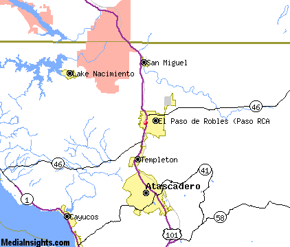
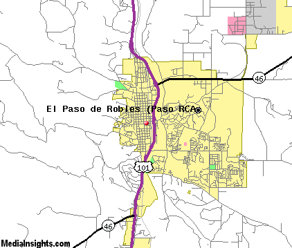
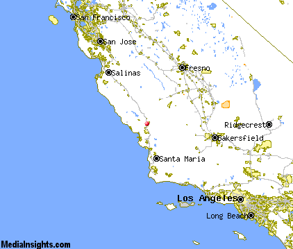
Paso Robles Map & Transportation
|

|
|
 |
|
|
| Click each thumbnail image to enlarge. |
 |
|
 |
 |
The closest airports in the area are the Paso Robles Municipal airport (PRB) located about 4 miles northeast of Paso Robles, the San Luis County Regional airport (SBP) located approximately 27 miles south of Paso Robles in San Luis Obispo, California, the New Coalinga Municipal airport (C80) located roughly 43 miles northeast of Paso Robles in Coalinga, California, and finally the Santa Maria Pub Cpt G Allan Hancock airport (SMX) located around 51 miles south of Paso Robles in Santa Maria, California.
|

|
Paso Robles Attractions
|

|
|
| | | Water Parks |
| The Island Waterpark and Family Fun Village | Fresno | CA | 92.9 mi. | | | Wild Water Adventures | Clovis | CA | 99.5 mi. | |
| | | Golf Courses |
| Huerhuero Creek Golf Course | Paso Robles | CA | | | | Hunter Ranch Golf Course | Paso Robles | CA | | | | Links Course at Paso Robles | Paso Robles | CA | | | | Paso Robles Golf Club | Paso Robles | CA | | | | Eagle Creek Golf Course | Atascadero | CA | 10.3 mi. | | | Chalk Mountain Golf Course | Atascadero | CA | 11.1 mi. | | | Morro Bay Golf Course | Morro Bay | CA | 19.4 mi. | | | Dairy Creek Golf Course | San Luis Obispo | CA | 24.4 mi. | | | Laguna Lake Golf Course | San Luis Obispo | CA | 24.4 mi. | |
| | | State Parks |
| Morro Bay State Park | | CA | 20.7 mi. | | | San Simeon Beach State Park | | CA | 24.4 mi. | | | Montana de Oro State Park | | CA | 27.1 mi. | |
| | | Museums |
| Hearst San Simeon State Historical Monument | San Simeon | CA | 28.1 mi. | (Art) |
| | | Zoos and Aquariums |
| Charles Paddock Zoo | Atascadero | CA | 9.6 mi. | | | Chaffee Zoological Gardens | Fresno | CA | 92.9 mi. | | | Monterey Bay Aquarium | Monterey | CA | 95.1 mi. | | | Santa Barbara Zoological Gardens | Santa Barbara | CA | 100.5 mi. | |
Notice a problem with the information on this page? Please notify us.
|
Disclaimer: We recommend you conduct your own research regarding all accomodations and attractions found on this website. The distances shown on this website are straight-line distances as the crow flies. The road distance may be considerably longer. You assume all liability for use of any information found on this website. No information is confirmed or warranted in any way. By using our services you agree to the terms and conditions of this disclaimer.
|
| We are the #1 site for your California Vacation presenting California vacation rentals, hotels, weather and map for each city. |
California Vacation and Hawaiian Vacation are publications and trademarks of Media Insights, Inc.
©1997-2025 All Rights Reserved.
|
|