 |
Baywood-Park
is a unique village that is part of the community of Los Osos, located just off scenic Highway 1 on the central coast of California. It is situated southeast of Morro Bay. If you're looking for a place in California that is truly off the beaten path, a place to enjoy the natural beauty of the state, Baywood Park in Los Osos is for you. It is literally surrounded by thousands of acres of open space, state parks and forests, nature preserves and coastline. Morro Bay State Beach, Montana de Oro State Park and the Los Padres National Forest are all just minutes away. Enjoy hiking, horseback riding, kayaking, fishing, swimming, surfing, parasailing, horseback riding or golf. It's all right at your fingertips. You can tour vineyards and hot springs, or charter a tour boat. Montana de Oro State Park has over 7,000 acres of secluded rocky shores, sandy beaches and wooded stream canyons for exploring. Many trails follow the edge of coastal bluffs, giving spectacular views of the ocean and, in the distance, Morro Rock. The village of Baywood Park is lined with quaint shops and art galleries, restaurants and cafes. The Baywood Park Pier overlooks the shores of the lagoon-like estuary and has a beautiful view of the Bay. Baywood Park is also host to a weekly Farmer's Market, held every Monday from 2:00 P.M. - 5:00 P.M., and featuring locally grown produce and flowers. Other key attractions in the area include the Scenic 7-Mile Drive, Los Osos Oaks State Reserve, Sweet Springs Nature Preserve, the Elfin Forest and the historic 1872 Los Osos Schoolhouse.
Surrounding areas: Morro Bay, California (3.8 mi), Cayucos, California (8.4 mi), San Luis Obispo, California (10.3 mi), Avila Beach, California (11.7 mi), Atascadero, California (14.8 mi), Pismo Beach, California (16.2 mi), Grover Beach, California (18.7 mi)
|

|
Baywood Park Vacation Rentals
|

|
|
|
|
|
Baywood Park Hotels and Resorts
|
|
|
| | | Hotels & Motels |
| Blue Heron | 1899 9TH St | Los Osos, CA | | (805) 528-1493 | | Inn At Morro Bay | 60 State Park Rd | Morro Bay, CA | 2.0 mi. | (805) 772-5651 | | Embarcadero Inn | 456 Embarcadero | Morro Bay, CA | 2.7 mi. | (805) 772-2700 | | Best Western San Marcos Motor Inn | 250 Pacific St | Morro Bay, CA | 2.8 mi. | (805) 772-2248 | | Ascot Suites | 260 Morro Bay Blvd | Morro Bay, CA | 2.9 mi. | (805) 772-4437 | | Bay View Lodge | 225 HBR St | Morro Bay, CA | 2.9 mi. | (805) 772-2771 | | The Inn At Morro Bay | 19 Country CLB Rd | Morro Bay, CA | 2.9 mi. | (805) 772-5651 | | Blue Sail Inn | 851 Market Ave | Morro Bay, CA | 3.0 mi. | (805) 772-7132 | | Days Inn Harbor House | 1095 Main St | Morro Bay, CA | 3.0 mi. | (800) 247-5076 | | Econo Lodge | 1100 Main St | Morro Bay, CA | 3.0 mi. | (805) 772-5609 | | Motel 6 | 298 Atascadero Rd | Morro Bay, CA | 3.9 mi. | (805) 772-5641 | | El Ranch Best Western | 2460 Main St | Morro Bay, CA | 4.3 mi. | (805) 772-2212 | | Beachwalker Inn | 501 S Ocean Ave | Cayucos, CA | 8.9 mi. | (805) 995-2133 | | Embassy Suites Hotel San Luis Obispo | 333 Madonna Rd | San Luis Obispo, CA | 9.8 mi. | (805) 549-0800 | | Best Western Royal Oak Motor Hotel | 214 Madonna Rd | San Luis Obispo, CA | 9.9 mi. | (805) 544-4410 | | Econo Lodge | 950 Olive St | San Luis Obispo, CA | 9.9 mi. | (805) 544-8886 | | Ramada Inn-San Luis Obispo | 1000 Olive St | San Luis Obispo, CA | 9.9 mi. | (800) 777-5847 | | Travelodge Downtown | 345 Marsh St | San Luis Obispo, CA | 10.0 mi. | (805) 543-6443 | | Motel 6 #138 | 1433 Calle Joaquin | San Luis Obispo, CA | 10.2 mi. | (805) 549-9595 | | Motel 6 | 1625 Calle Joaquin | San Luis Obispo, CA | 10.3 mi. | (805) 541-6992 | | Comfort Inn & Suites Lamplighter | 1604 Monterey St | San Luis Obispo, CA | 10.6 mi. | (805) 547-7777 | | Holiday Inn Express | 1800 Monterey St | San Luis Obispo, CA | 10.6 mi. | (805) 544-8600 | | Quality Suites | 1631 Monterey St | San Luis Obispo, CA | 10.6 mi. | (805) 541-5001 | | Travelodge | 1825 Monterey St | San Luis Obispo, CA | 10.6 mi. | (805) 543-5110 | | Apple Farm Inn | 2015 Monterey St | San Luis Obispo, CA | 10.7 mi. | (805) 544-1317 | | Best Western Somerset Inn | 1895 Monterey St | San Luis Obispo, CA | 10.7 mi. | (805) 544-0973 | | Days Inn | 2050 Garfield St | San Luis Obispo, CA | 10.7 mi. | (805) 549-9911 | | La Cuesta Motor Inn | 2074 Monterey St | San Luis Obispo, CA | 10.7 mi. | (805) 543-2777 | | Sands Suites & Motel | 1930 Monterey St | San Luis Obispo, CA | 10.7 mi. | (805) 544-0500 | | Super 8 Motel | 1951 Monterey St | San Luis Obispo, CA | 10.7 mi. | (805) 544-7895 | | Cliffs Resort At Shell Beach | 2757 Shell Beach Rd | Shell Beach, CA | 13.8 mi. | (805) 773-5000 | | Spyglass Inn | 2705 Spyglass Dr | Shell Beach, CA | 14.0 mi. | (805) 773-4855 | | Motel 6 #351 | 9400 El Camino Real | Atascadero, CA | 14.2 mi. | (805) 466-6701 | | Best Western Colony Inn | 3600 El Camino Real | Atascadero, CA | 14.7 mi. | (805) 466-4449 | | Best Western Shore Cliff Lodge | 2555 Price St | Pismo Beach, CA | 15.9 mi. | (805) 773-4671 | | Cottage Inn By The Sea | 2351 Price St | Pismo Beach, CA | 16.0 mi. | (805) 773-4617 | | Pismo Lighthouse Suites | 2411 Price St | Pismo Beach, CA | 16.0 mi. | (805) 245-2411 | | Kon Tiki Inn | 1621 Price St | Pismo Beach, CA | 16.3 mi. | (805) 773-4833 | | Shell Beach Motel | 653 Shell BCH Rd | Pismo Beach, CA | 16.8 mi. | (805) 773-4373 | | Sandcastle Inn | 100 Stimson Ave | Pismo Beach, CA | 17.0 mi. | (805) 773-2422 |

|
Baywood Park Weather & Climate
|

|
|
|
Very mild weather all year long, similar to a Mediterranean climate, is what you'll find along the south-central coast of California. Located between Monterey County and Santa Barbara, this area of the coast enjoys almost ideal weather and over 300 days of sunshine per year. The terrain is made up of gently rolling hills and sand dunes, lush foliage and vineyards. It is known to have some of the best weather on the Central Coast. Cool ocean breezes keep temperatures from becoming too hot in the summer and the latitude and oceanic effects keeps things mild in winter. Low clouds and patchy fog are often reported often on summer days, but it almost always burns off by noontime. Precipitation in the form of rain falls November through March.
|
| Month |
High Temp |
Low Temp |
Rainfall |
Ocean Temp |
| January |
61°F |
42°F |
3.49 in. |
54°F |
| February |
62°F |
43°F |
3.69 in. |
54°F |
| March |
62°F |
44°F |
3.66 in. |
54°F |
| April |
63°F |
45°F |
1.12 in. |
54°F |
| May |
62°F |
47°F |
0.34 in. |
54°F |
| June |
64°F |
50°F |
0.07 in. |
56°F |
| July |
65°F |
52°F |
0.03 in. |
57°F |
| August |
66°F |
53°F |
0.09 in. |
58°F |
| September |
67°F |
52°F |
0.37 in. |
58°F |
| October |
68°F |
49°F |
0.70 in. |
57°F |
| November |
66°F |
45°F |
1.54 in. |
56°F |
| December |
62°F |
41°F |
2.51 in. |
55°F |

|
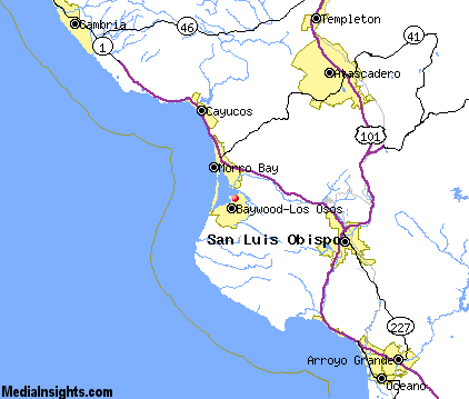
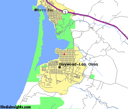
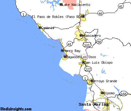
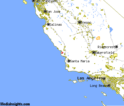
Baywood Park Map & Transportation
|

|
|
 |
|
|
| Click each thumbnail image to enlarge. |
 |
|
 |
 |
The closest airports in the area are the San Luis County Regional airport (SBP) located about 12 miles southeast of Baywood Park in San Luis Obispo, California, the Paso Robles Municipal airport (PRB) located approximately 26 miles northeast of Baywood Park in Paso Robles, California, the Santa Maria Pub Cpt G Allan Hancock airport (SMX) located roughly 36 miles southeast of Baywood Park in Santa Maria, California, and finally the New Coalinga Municipal airport (C80) located around 65 miles northeast of Baywood Park in Coalinga, California.
|

|
Baywood Park Attractions
|

|
|
| | | Water Parks |
| The Island Waterpark and Family Fun Village | Fresno | CA | 114.8 mi. | |
| | | Golf Courses |
| Morro Bay Golf Course | Morro Bay | CA | 3.8 mi. | | | Dairy Creek Golf Course | San Luis Obispo | CA | 10.3 mi. | | | Laguna Lake Golf Course | San Luis Obispo | CA | 10.3 mi. | | | Eagle Creek Golf Course | Atascadero | CA | 14.4 mi. | | | Chalk Mountain Golf Course | Atascadero | CA | 14.7 mi. | | | Pismo State Beach Golf Course | Grover Beach | CA | 17.9 mi. | | | Huerhuero Creek Golf Course | Paso Robles | CA | 22.3 mi. | | | Links Course at Paso Robles | Paso Robles | CA | 22.3 mi. | | | Paso Robles Golf Club | Paso Robles | CA | 22.3 mi. | | | Hunter Ranch Golf Course | Paso Robles | CA | 25.1 mi. | | | Blacklake Golf Course | Nipomo | CA | 28.2 mi. | |
| | | State Parks |
| Morro Bay State Park | | CA | 1.6 mi. | | | Montana de Oro State Park | | CA | 4.8 mi. | | | San Simeon Beach State Park | | CA | 23.8 mi. | | | Point Sal Beach State Park | | CA | 31.4 mi. | |
| | | Museums |
| Hearst San Simeon State Historical Monument | San Simeon | CA | 29.7 mi. | (Art) |
| | | Zoos and Aquariums |
| Charles Paddock Zoo | Atascadero | CA | 14.6 mi. | | | Santa Barbara Zoological Gardens | Santa Barbara | CA | 89.8 mi. | | | Monterey Bay Aquarium | Monterey | CA | 106.1 mi. | | | Chaffee Zoological Gardens | Fresno | CA | 114.8 mi. | |
Notice a problem with the information on this page? Please notify us.
|
Disclaimer: We recommend you conduct your own research regarding all accomodations and attractions found on this website. The distances shown on this website are straight-line distances as the crow flies. The road distance may be considerably longer. You assume all liability for use of any information found on this website. No information is confirmed or warranted in any way. By using our services you agree to the terms and conditions of this disclaimer.
|
| We are the #1 site for your California Vacation presenting California vacation rentals, hotels, weather and map for each city. |
California Vacation and Hawaiian Vacation are publications and trademarks of Media Insights, Inc.
©1997-2025 All Rights Reserved.
|
|