 |
Atascadero
is a lovely town of approximately 27,000, located in Central California, about 15 miles north of San Luis Obispo and 17 miles inland from Morro Bay. It is near Highway 101 and the Pacific Ocean. The city sits among gently rolling hills and native California oaks in a picturesque area that is home to many farms, orchards and wineries. Atascadero Lake, Lake Naciemento and Santa Margarita Lake all offer a variety of recreational opportunities, and the wineries offer tasting and touring. There are also four public golf courses near Atascadero, and the town is home to the famous Charles Paddock Zoo and Atascadero Lake Park. The lake is a popular spot for many community events, including Tuesday Evenings in the Park Barbecue and a free band concert series, held throughout the summer months. Nearby, the Los Padres National Forest offers miles of hiking trails and hundreds of miles of back roads are perfect for cyclists. Altascadero is also host to a weekly Farmer's Market, held every Wednesday evening, year round. The Pacific Coast beaches are just a short drive away and offer swimming, fishing, surfing and sightseeing. Other special events include the annual Atascadero Wine Festival, usually held in June, Colony Days & Tent City in October and the Pine Mountain Festival, which takes place in April in Stadium Park in Atascadero.
Surrounding areas: Paso Robles, California (10.8 mi), Morro Bay, California (13.4 mi), San Luis Obispo, California (13.9 mi), Cayucos, California (14.0 mi), Baywood Park, California (14.8 mi), Los Osos, California (15.2 mi), Avila Beach, California (20.9 mi)
|

|
Atascadero Vacation Rentals
|

|
|
|
|
|
Atascadero Hotels and Resorts
|
|
|
| | | Hotels & Motels |
| Best Western Colony Inn | 3600 El Camino Real | Atascadero, CA | | (805) 466-4449 | | Motel 6 #351 | 9400 El Camino Real | Atascadero, CA | | (805) 466-6701 | | Adelaide Motor Inn | 1215 Ysabell Ave | Paso Robles, CA | 10.8 mi. | (805) 238-2770 | | Hampton Inn & Suites | 212 Alexa Court | Paso Robles, CA | 10.8 mi. | (805) 226-9988 | | La Bellasera Hotel & Suites | 206 Alexa Ct | Paso Robles, CA | 10.8 mi. | (805) 238-2834 | | Travelodge Paso Robles | 2701 SPG St | Paso Robles, CA | 10.8 mi. | (805) 238-0078 | | Best Western Black Oak Motor Lodge | 1135 24TH St | Paso Robles, CA | 11.7 mi. | (805) 238-4740 | | Holiday Inn Express | 2455 Riverside Ave | Paso Robles, CA | 11.7 mi. | (805) 238-6500 | | Motel 6 #1372 | 1134 Black Oak Dr | Paso Royales, CA | 11.9 mi. | (805) 239-9090 | | Days Inn | 2050 Garfield St | San Luis Obispo, CA | 12.7 mi. | (805) 549-9911 | | Apple Farm Inn | 2015 Monterey St | San Luis Obispo, CA | 12.8 mi. | (805) 544-1317 | | La Cuesta Motor Inn | 2074 Monterey St | San Luis Obispo, CA | 12.8 mi. | (805) 543-2777 | | Sands Suites & Motel | 1930 Monterey St | San Luis Obispo, CA | 12.8 mi. | (805) 544-0500 | | Super 8 Motel | 1951 Monterey St | San Luis Obispo, CA | 12.8 mi. | (805) 544-7895 | | Best Western Somerset Inn | 1895 Monterey St | San Luis Obispo, CA | 12.9 mi. | (805) 544-0973 | | Holiday Inn Express | 1800 Monterey St | San Luis Obispo, CA | 12.9 mi. | (805) 544-8600 | | Travelodge | 1825 Monterey St | San Luis Obispo, CA | 12.9 mi. | (805) 543-5110 | | Comfort Inn & Suites Lamplighter | 1604 Monterey St | San Luis Obispo, CA | 13.0 mi. | (805) 547-7777 | | Quality Suites | 1631 Monterey St | San Luis Obispo, CA | 13.0 mi. | (805) 541-5001 | | Econo Lodge | 950 Olive St | San Luis Obispo, CA | 13.1 mi. | (805) 544-8886 | | Ramada Inn-San Luis Obispo | 1000 Olive St | San Luis Obispo, CA | 13.1 mi. | (800) 777-5847 | | El Ranch Best Western | 2460 Main St | Morro Bay, CA | 13.4 mi. | (805) 772-2212 | | Motel 6 | 298 Atascadero Rd | Morro Bay, CA | 13.5 mi. | (805) 772-5641 | | Bay View Lodge | 225 HBR St | Morro Bay, CA | 13.7 mi. | (805) 772-2771 | | Days Inn Harbor House | 1095 Main St | Morro Bay, CA | 13.7 mi. | (800) 247-5076 | | Econo Lodge | 1100 Main St | Morro Bay, CA | 13.7 mi. | (805) 772-5609 | | The Inn At Morro Bay | 19 Country CLB Rd | Morro Bay, CA | 13.7 mi. | (805) 772-5651 | | Ascot Suites | 260 Morro Bay Blvd | Morro Bay, CA | 13.8 mi. | (805) 772-4437 | | Best Western San Marcos Motor Inn | 250 Pacific St | Morro Bay, CA | 13.9 mi. | (805) 772-2248 | | Blue Sail Inn | 851 Market Ave | Morro Bay, CA | 13.9 mi. | (805) 772-7132 | | Travelodge Downtown | 345 Marsh St | San Luis Obispo, CA | 13.9 mi. | (805) 543-6443 | | Embarcadero Inn | 456 Embarcadero | Morro Bay, CA | 14.0 mi. | (805) 772-2700 | | Inn At Morro Bay | 60 State Park Rd | Morro Bay, CA | 14.0 mi. | (805) 772-5651 | | Beachwalker Inn | 501 S Ocean Ave | Cayucos, CA | 14.3 mi. | (805) 995-2133 | | Best Western Royal Oak Motor Hotel | 214 Madonna Rd | San Luis Obispo, CA | 14.7 mi. | (805) 544-4410 | | Embassy Suites Hotel San Luis Obispo | 333 Madonna Rd | San Luis Obispo, CA | 14.8 mi. | (805) 549-0800 | | Blue Heron | 1899 9TH St | Los Osos, CA | 15.2 mi. | (805) 528-1493 | | Motel 6 #138 | 1433 Calle Joaquin | San Luis Obispo, CA | 15.8 mi. | (805) 549-9595 | | Motel 6 | 1625 Calle Joaquin | San Luis Obispo, CA | 16.3 mi. | (805) 541-6992 | | Cliffs Resort At Shell Beach | 2757 Shell Beach Rd | Shell Beach, CA | 21.6 mi. | (805) 773-5000 |

|
Atascadero Weather & Climate
|

|
|
|
The Salinas Valley, located in Central California, approximately 25 miles inland from the Pacific Ocean, is home to Lake Nacimiento, and towns such as Kings City and Paso Robles. This area of rich, fertile farmlands and lush forest has been dubbed the "Salad Bowl of the Nation." The climate experiences greater contrasts in seasons than coastal areas, although the weather is greatly influenced by the Pacific Ocean. It has warmer summers and cooler winters than cities located right along the coast, and receives approximately 11.27 inches of rainfall per year in the winter months. Trace amounts of rain falls between April and October. Afternoon sea breezes are common, with low clouds and fog nearer the coast. The area is home to many natural hot springs and grapes grown for wine thrive in the local climate.
|
| Month |
High Temp |
Low Temp |
Rainfall |
Ocean Temp |
| January |
61°F |
33°F |
6.98 in. |
54°F |
| February |
64°F |
36°F |
6.88 in. |
54°F |
| March |
67°F |
39°F |
5.97 in. |
54°F |
| April |
73°F |
40°F |
1.83 in. |
54°F |
| May |
79°F |
44°F |
0.56 in. |
55°F |
| June |
86°F |
48°F |
0.10 in. |
57°F |
| July |
91°F |
51°F |
0.03 in. |
58°F |
| August |
92°F |
51°F |
0.10 in. |
58°F |
| September |
88°F |
48°F |
0.49 in. |
58°F |
| October |
80°F |
42°F |
1.57 in. |
57°F |
| November |
68°F |
35°F |
3.17 in. |
56°F |
| December |
61°F |
30°F |
4.49 in. |
55°F |

|
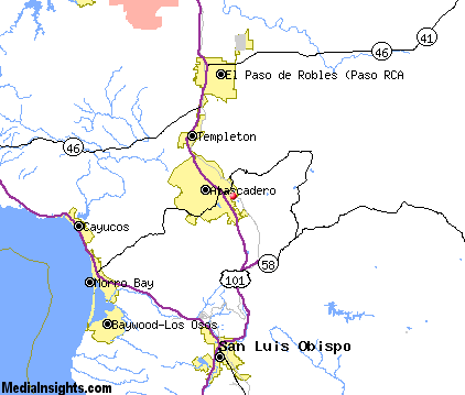
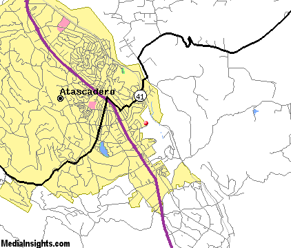
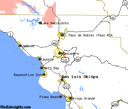
Atascadero Map & Transportation
|

|
|
 |
|
|
| Click each thumbnail image to enlarge. |
 |
|
 |
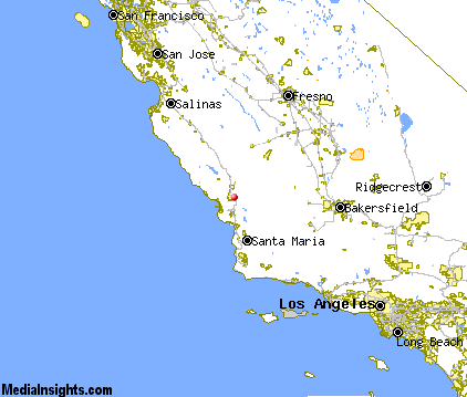 |
The closest airports in the area are the Paso Robles Municipal airport (PRB) located about 13 miles north of Atascadero in Paso Robles, California, the San Luis County Regional airport (SBP) located approximately 16 miles south of Atascadero in San Luis Obispo, California, the Santa Maria Pub Cpt G Allan Hancock airport (SMX) located roughly 41 miles south of Atascadero in Santa Maria, California, and finally the New Coalinga Municipal airport (C80) located around 51 miles northeast of Atascadero in Coalinga, California.
|

|
Atascadero Attractions
|

|
|
| | | Water Parks |
| The Island Waterpark and Family Fun Village | Fresno | CA | 100.6 mi. | | | Wild Water Adventures | Clovis | CA | 107.1 mi. | |
| | | Golf Courses |
| Chalk Mountain Golf Course | Atascadero | CA | | | | Eagle Creek Golf Course | Atascadero | CA | | | | Huerhuero Creek Golf Course | Paso Robles | CA | 10.8 mi. | | | Links Course at Paso Robles | Paso Robles | CA | 10.8 mi. | | | Paso Robles Golf Club | Paso Robles | CA | 10.8 mi. | | | Hunter Ranch Golf Course | Paso Robles | CA | 11.9 mi. | | | Morro Bay Golf Course | Morro Bay | CA | 13.4 mi. | | | Dairy Creek Golf Course | San Luis Obispo | CA | 13.9 mi. | | | Laguna Lake Golf Course | San Luis Obispo | CA | 13.9 mi. | | | Pismo State Beach Golf Course | Grover Beach | CA | 24.2 mi. | |
| | | State Parks |
| Morro Bay State Park | | CA | 13.5 mi. | | | Montana de Oro State Park | | CA | 19.1 mi. | | | San Simeon Beach State Park | | CA | 27.6 mi. | | | Point Sal Beach State Park | | CA | 39.7 mi. | |
| | | Museums |
| Hearst San Simeon State Historical Monument | San Simeon | CA | 32.7 mi. | (Art) |
| | | Zoos and Aquariums |
| Charles Paddock Zoo | Atascadero | CA | | | | Santa Barbara Zoological Gardens | Santa Barbara | CA | 90.5 mi. | | | Chaffee Zoological Gardens | Fresno | CA | 100.6 mi. | | | Monterey Bay Aquarium | Monterey | CA | 104.5 mi. | |
Notice a problem with the information on this page? Please notify us.
|
Disclaimer: We recommend you conduct your own research regarding all accomodations and attractions found on this website. The distances shown on this website are straight-line distances as the crow flies. The road distance may be considerably longer. You assume all liability for use of any information found on this website. No information is confirmed or warranted in any way. By using our services you agree to the terms and conditions of this disclaimer.
|
| We are the #1 site for your California Vacation presenting California vacation rentals, hotels, weather and map for each city. |
California Vacation and Hawaiian Vacation are publications and trademarks of Media Insights, Inc.
©1997-2025 All Rights Reserved.
|
|