 |
Morro-Bay
is a lovely town that sits along the Pacific Coast about halfway between San Francisco and Los Angeles. Explorer Juan Rodriguez Cabrill, during his 16th century voyage of discovery, named the town's famous landmark, Morro Rock. Morro Bay is a working fishing village with pleasant year round weather, and a slow, easy way of life. The surrounding terrain is a combination of ocean scenery, rolling hills, year round lush landscaping and flowers. Tourism is the town's second largest industry, where people come to walk the beach, swim, sail, birdwatch or whale watch, play golf, eat delicious fresh seafood, or visit the nearby wineries. Boat rentals are available for visitors who want to enjoy the spirit of the Bay. The spectacular Hearst Castle and Montana de Oro State Park are also just a short drive from Morro Bay. The town of Morro Bay holds several colorful special events during the year, starting with Morro Bay Winter Bird Festival and Morro Bay Jazz Festival. Each December, the town celebrates the holidays with a Christmas Street Faire and a Lighted Boat Parade on the waterfront. For a relaxing, tranquil time at the ocean, away from crowds, noise and traffic, a visit to Morro Bay fits the bill.
Surrounding areas: Baywood Park, California (3.8 mi), Los Osos, California (4.4 mi), Cayucos, California (4.6 mi), San Luis Obispo, California (12.9 mi), Atascadero, California (13.4 mi), Avila Beach, California (15.4 mi), Cambria, California (17.9 mi)
|

|
Morro Bay Vacation Rentals
|

|
|
|
|
|
Morro Bay Hotels and Resorts
|
|
|
| | | Hotels & Motels |
| Ascot Suites | 260 Morro Bay Blvd | Morro Bay, CA | | (805) 772-4437 | | Bay View Lodge | 225 HBR St | Morro Bay, CA | | (805) 772-2771 | | Best Western San Marcos Motor Inn | 250 Pacific St | Morro Bay, CA | | (805) 772-2248 | | Blue Sail Inn | 851 Market Ave | Morro Bay, CA | | (805) 772-7132 | | Days Inn Harbor House | 1095 Main St | Morro Bay, CA | | (800) 247-5076 | | Econo Lodge | 1100 Main St | Morro Bay, CA | | (805) 772-5609 | | El Ranch Best Western | 2460 Main St | Morro Bay, CA | | (805) 772-2212 | | Embarcadero Inn | 456 Embarcadero | Morro Bay, CA | | (805) 772-2700 | | Inn At Morro Bay | 60 State Park Rd | Morro Bay, CA | | (805) 772-5651 | | Motel 6 | 298 Atascadero Rd | Morro Bay, CA | | (805) 772-5641 | | The Inn At Morro Bay | 19 Country CLB Rd | Morro Bay, CA | | (805) 772-5651 | | Blue Heron | 1899 9TH St | Los Osos, CA | 4.4 mi. | (805) 528-1493 | | Beachwalker Inn | 501 S Ocean Ave | Cayucos, CA | 5.2 mi. | (805) 995-2133 | | Econo Lodge | 950 Olive St | San Luis Obispo, CA | 12.4 mi. | (805) 544-8886 | | Ramada Inn-San Luis Obispo | 1000 Olive St | San Luis Obispo, CA | 12.4 mi. | (800) 777-5847 | | Best Western Colony Inn | 3600 El Camino Real | Atascadero, CA | 12.7 mi. | (805) 466-4449 | | Embassy Suites Hotel San Luis Obispo | 333 Madonna Rd | San Luis Obispo, CA | 12.7 mi. | (805) 549-0800 | | Travelodge Downtown | 345 Marsh St | San Luis Obispo, CA | 12.7 mi. | (805) 543-6443 | | Best Western Royal Oak Motor Hotel | 214 Madonna Rd | San Luis Obispo, CA | 12.8 mi. | (805) 544-4410 | | Comfort Inn & Suites Lamplighter | 1604 Monterey St | San Luis Obispo, CA | 12.9 mi. | (805) 547-7777 | | Quality Suites | 1631 Monterey St | San Luis Obispo, CA | 12.9 mi. | (805) 541-5001 | | Motel 6 #351 | 9400 El Camino Real | Atascadero, CA | 13.0 mi. | (805) 466-6701 | | Apple Farm Inn | 2015 Monterey St | San Luis Obispo, CA | 13.0 mi. | (805) 544-1317 | | Best Western Somerset Inn | 1895 Monterey St | San Luis Obispo, CA | 13.0 mi. | (805) 544-0973 | | Days Inn | 2050 Garfield St | San Luis Obispo, CA | 13.0 mi. | (805) 549-9911 | | Holiday Inn Express | 1800 Monterey St | San Luis Obispo, CA | 13.0 mi. | (805) 544-8600 | | La Cuesta Motor Inn | 2074 Monterey St | San Luis Obispo, CA | 13.0 mi. | (805) 543-2777 | | Sands Suites & Motel | 1930 Monterey St | San Luis Obispo, CA | 13.0 mi. | (805) 544-0500 | | Super 8 Motel | 1951 Monterey St | San Luis Obispo, CA | 13.0 mi. | (805) 544-7895 | | Travelodge | 1825 Monterey St | San Luis Obispo, CA | 13.0 mi. | (805) 543-5110 | | Motel 6 #138 | 1433 Calle Joaquin | San Luis Obispo, CA | 13.3 mi. | (805) 549-9595 | | Motel 6 | 1625 Calle Joaquin | San Luis Obispo, CA | 13.5 mi. | (805) 541-6992 | | Cliffs Resort At Shell Beach | 2757 Shell Beach Rd | Shell Beach, CA | 17.5 mi. | (805) 773-5000 | | Spyglass Inn | 2705 Spyglass Dr | Shell Beach, CA | 17.6 mi. | (805) 773-4855 | | Cambria Pines Lodge | 2905 Burton Dr | Cambria, CA | 17.8 mi. | (805) 927-4200 | | Burton Drive Inn - Sylvia's | 4022 Burton Dr | Cambria, CA | 18.0 mi. | (805) 927-5125 | | Creekside Inn | 2618 Main St | Cambria, CA | 18.0 mi. | (805) 927-4021 | | Best Western Fireside Inn | 6700 Moonstone Beach | Cambria, CA | 18.1 mi. | (805) 927-8661 | | White Water Inn | 6790 Moonstone BCH Dr | Cambria, CA | 18.1 mi. | (805) 927-1066 | | Adelaide Motor Inn | 1215 Ysabell Ave | Paso Robles, CA | 19.4 mi. | (805) 238-2770 |

|
Morro Bay Weather & Climate
|

|
|
|
Very mild weather all year long, similar to a Mediterranean climate, is what you'll find along the south-central coast of California. Located between Monterey County and Santa Barbara, this area of the coast enjoys almost ideal weather and over 300 days of sunshine per year. The terrain is made up of gently rolling hills and sand dunes, lush foliage and vineyards. It is known to have some of the best weather on the Central Coast. Cool ocean breezes keep temperatures from becoming too hot in the summer and the latitude and oceanic effects keeps things mild in winter. Low clouds and patchy fog are often reported often on summer days, but it almost always burns off by noontime. Precipitation in the form of rain falls November through March.
|
| Month |
High Temp |
Low Temp |
Rainfall |
Ocean Temp |
| January |
61°F |
42°F |
3.49 in. |
54°F |
| February |
62°F |
43°F |
3.69 in. |
54°F |
| March |
62°F |
44°F |
3.66 in. |
54°F |
| April |
63°F |
45°F |
1.12 in. |
54°F |
| May |
62°F |
47°F |
0.34 in. |
54°F |
| June |
64°F |
50°F |
0.07 in. |
56°F |
| July |
65°F |
52°F |
0.03 in. |
57°F |
| August |
66°F |
53°F |
0.09 in. |
58°F |
| September |
67°F |
52°F |
0.37 in. |
58°F |
| October |
68°F |
49°F |
0.70 in. |
57°F |
| November |
66°F |
45°F |
1.54 in. |
56°F |
| December |
62°F |
41°F |
2.51 in. |
55°F |

|
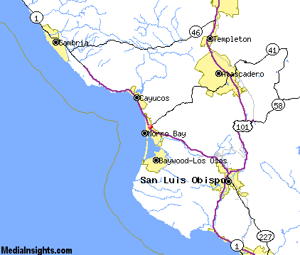
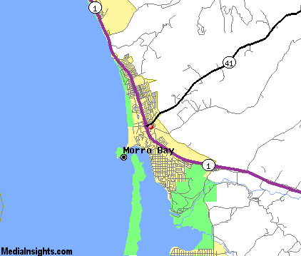
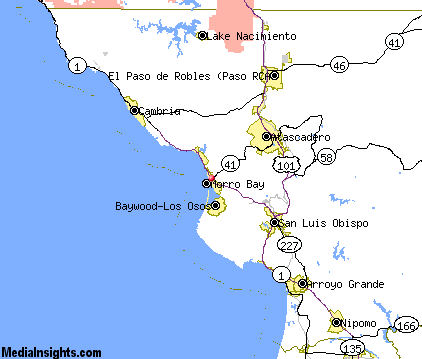
Morro Bay Map & Transportation
|

|
|
 |
|
|
| Click each thumbnail image to enlarge. |
 |
|
 |
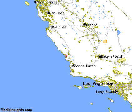 |
The closest airports in the area are the San Luis County Regional airport (SBP) located about 15 miles southeast of Morro Bay in San Luis Obispo, California, the Paso Robles Municipal airport (PRB) located approximately 23 miles northeast of Morro Bay in Paso Robles, California, the Santa Maria Pub Cpt G Allan Hancock airport (SMX) located roughly 40 miles southeast of Morro Bay in Santa Maria, California, and finally the New Coalinga Municipal airport (C80) located around 62 miles northeast of Morro Bay in Coalinga, California.
|

|
Morro Bay Attractions
|

|
|
| | | Water Parks |
| The Island Waterpark and Family Fun Village | Fresno | CA | 112.2 mi. | | | Wild Water Adventures | Clovis | CA | 118.8 mi. | |
| | | Golf Courses |
| Morro Bay Golf Course | Morro Bay | CA | | | | Dairy Creek Golf Course | San Luis Obispo | CA | 12.9 mi. | | | Eagle Creek Golf Course | Atascadero | CA | 12.9 mi. | | | Laguna Lake Golf Course | San Luis Obispo | CA | 12.9 mi. | | | Chalk Mountain Golf Course | Atascadero | CA | 13.5 mi. | | | Huerhuero Creek Golf Course | Paso Robles | CA | 19.4 mi. | | | Links Course at Paso Robles | Paso Robles | CA | 19.4 mi. | | | Paso Robles Golf Club | Paso Robles | CA | 19.4 mi. | | | Pismo State Beach Golf Course | Grover Beach | CA | 21.5 mi. | | | Hunter Ranch Golf Course | Paso Robles | CA | 22.5 mi. | |
| | | State Parks |
| Morro Bay State Park | | CA | 2.4 mi. | | | Montana de Oro State Park | | CA | 8.2 mi. | | | San Simeon Beach State Park | | CA | 20.4 mi. | | | Point Sal Beach State Park | | CA | 35.2 mi. | |
| | | Museums |
| Hearst San Simeon State Historical Monument | San Simeon | CA | 26.3 mi. | (Art) |
| | | Zoos and Aquariums |
| Charles Paddock Zoo | Atascadero | CA | 12.9 mi. | | | Santa Barbara Zoological Gardens | Santa Barbara | CA | 93.2 mi. | | | Monterey Bay Aquarium | Monterey | CA | 102.5 mi. | | | Chaffee Zoological Gardens | Fresno | CA | 112.2 mi. | |
Notice a problem with the information on this page? Please notify us.
|
Disclaimer: We recommend you conduct your own research regarding all accomodations and attractions found on this website. The distances shown on this website are straight-line distances as the crow flies. The road distance may be considerably longer. You assume all liability for use of any information found on this website. No information is confirmed or warranted in any way. By using our services you agree to the terms and conditions of this disclaimer.
|
| We are the #1 site for your California Vacation presenting California vacation rentals, hotels, weather and map for each city. |
California Vacation and Hawaiian Vacation are publications and trademarks of Media Insights, Inc.
©1997-2025 All Rights Reserved.
|
|