 |
Pismo-Beach
is famous for two things - the beach that is one of California's longest and widest stretches of beach, and for their annual events and festivals. Located along the central coast in San Luis Obispo, Pismo Beach is home to the Clam Festival, a Custom Car Show and annual Jazz Festival. The beautiful beach is 23 miles of swimming, sunning, surfing, volleyball playing, and kite flying! There are miles of trails in town and along the coast for hiking and bike riding, and horseback riding is allowed on the fabulous Oceano Dunes and Beach. For a different and very fun way to tour the coastline, kayaks and canoes are available for rent. Just a short drive from Pismo Beach takes you to the spectacular Hearst Castle, local wineries, championship golf courses and the charming Danish town of Solvang. In town, you'll be delighted with the numerous restaurants, art galleries, antique and specialty shops and souvenir shops. A local farmer's market is held every Tuesday, June through August. Lodging in Pismo Beach is abundant and everything from an inn on a bluff overlooking the ocean, to family hotels and motels. The weather along the central coast is mild, 60s - 80s, with the warmest months being August - October, so plan a trip to Pismo Beach anytime of the year!
Surrounding areas: Grover Beach, California (2.5 mi), Oceano, California (3.8 mi), Avila Beach, California (5.2 mi), San Luis Obispo, California (8.8 mi), Nipomo, California (12.1 mi), Arroyo Grande, California (12.6 mi), Los Osos, California (15.7 mi)
|

|
Pismo Beach Vacation Rentals
|

|
|
|
|
|
Pismo Beach Hotels and Resorts
|
|
|
| | | Hotels & Motels |
| Best Western Shore Cliff Lodge | 2555 Price St | Pismo Beach, CA | | (805) 773-4671 | | Cottage Inn By The Sea | 2351 Price St | Pismo Beach, CA | | (805) 773-4617 | | Kon Tiki Inn | 1621 Price St | Pismo Beach, CA | | (805) 773-4833 | | Mission Inn Of Pismo Beach | 601 James Way | Pismo Beach, CA | | (805) 773-6020 | | Motel 6 #270 | 860 4TH St | Pismo Beach, CA | | (805) 773-2665 | | Oxford Suites | 651 Five Cities Dr | Pismo Beach, CA | | (800) 982-7848 | | Pismo Lighthouse Suites | 2411 Price St | Pismo Beach, CA | | (805) 245-2411 | | Sandcastle Inn | 100 Stimson Ave | Pismo Beach, CA | | (805) 773-2422 | | Shell Beach Motel | 653 Shell BCH Rd | Pismo Beach, CA | | (805) 773-4373 | | Spyglass Inn | 2705 Spyglass Dr | Shell Beach, CA | 2.5 mi. | (805) 773-4855 | | Cliffs Resort At Shell Beach | 2757 Shell Beach Rd | Shell Beach, CA | 2.6 mi. | (805) 773-5000 | | Best Western Casa Grande Inn | 850 Oak Park Rd | Arroyo Grande, CA | 2.7 mi. | (805) 481-7398 | | E Z 8 Motels Inc | 555 Camino Mercado | Arroyo Grande, CA | 3.1 mi. | (805) 481-4774 | | Pacific Plaza Resort | 444 Pier Ave | Oceano, CA | 3.1 mi. | (805) 473-6989 | | Holiday Inn Express | 775 N Oak Park | Grover Beach, CA | 5.1 mi. | (805) 481-4448 | | Motel 6 | 1625 Calle Joaquin | San Luis Obispo, CA | 6.7 mi. | (805) 541-6992 | | Motel 6 #138 | 1433 Calle Joaquin | San Luis Obispo, CA | 7.2 mi. | (805) 549-9595 | | Embassy Suites Hotel San Luis Obispo | 333 Madonna Rd | San Luis Obispo, CA | 8.1 mi. | (805) 549-0800 | | Best Western Royal Oak Motor Hotel | 214 Madonna Rd | San Luis Obispo, CA | 8.2 mi. | (805) 544-4410 | | Travelodge Downtown | 345 Marsh St | San Luis Obispo, CA | 8.8 mi. | (805) 543-6443 | | Econo Lodge | 950 Olive St | San Luis Obispo, CA | 9.5 mi. | (805) 544-8886 | | Comfort Inn & Suites Lamplighter | 1604 Monterey St | San Luis Obispo, CA | 9.6 mi. | (805) 547-7777 | | Quality Suites | 1631 Monterey St | San Luis Obispo, CA | 9.6 mi. | (805) 541-5001 | | Ramada Inn-San Luis Obispo | 1000 Olive St | San Luis Obispo, CA | 9.6 mi. | (800) 777-5847 | | Best Western Somerset Inn | 1895 Monterey St | San Luis Obispo, CA | 9.7 mi. | (805) 544-0973 | | Holiday Inn Express | 1800 Monterey St | San Luis Obispo, CA | 9.7 mi. | (805) 544-8600 | | Travelodge | 1825 Monterey St | San Luis Obispo, CA | 9.7 mi. | (805) 543-5110 | | Apple Farm Inn | 2015 Monterey St | San Luis Obispo, CA | 9.8 mi. | (805) 544-1317 | | Days Inn | 2050 Garfield St | San Luis Obispo, CA | 9.8 mi. | (805) 549-9911 | | La Cuesta Motor Inn | 2074 Monterey St | San Luis Obispo, CA | 9.8 mi. | (805) 543-2777 | | Sands Suites & Motel | 1930 Monterey St | San Luis Obispo, CA | 9.8 mi. | (805) 544-0500 | | Super 8 Motel | 1951 Monterey St | San Luis Obispo, CA | 9.8 mi. | (805) 544-7895 | | Blue Heron | 1899 9TH St | Los Osos, CA | 15.7 mi. | (805) 528-1493 | | Holiday In Hotel & Suites | 2100 N Broadway | Santa Maria, CA | 16.9 mi. | (805) 928-6000 | | Best Western Big America | 1725 N Broadway | Santa Maria, CA | 17.2 mi. | (805) 922-5200 | | Inn At Morro Bay | 60 State Park Rd | Morro Bay, CA | 18.0 mi. | (805) 772-5651 | | Town Center Hotel | 215 N Broadway | Santa Maria, CA | 18.0 mi. | (805) 925-6163 | | Motel 6 #675 | 2040 N Preisler Ln | Santa Maria, CA | 18.1 mi. | (805) 928-8111 | | Radisson Hotel Santa Maria | 3455 Skwy Dr | Santa Maria, CA | 18.1 mi. | (805) 928-8000 | | Santa Maria Inn | 801 S Broadway | Santa Maria, CA | 18.5 mi. | (805) 928-7777 |

|
Pismo Beach Weather & Climate
|

|
|
|
A Mild, Mediterranean climate describes the central coast of California that lies between San Francisco and Los Angeles. The area near San Luis Obispo and Pismo Beach enjoys over 300 days of sunshine per year and very pleasant temperatures year round.
The terrain is made up of sandy beaches, gently rolling hills and sand dunes, lush foliage and vineyards. Cool ocean breezes keep temperatures from becoming too hot in the summertime. Low clouds and patchy fog are common on summer days, but it almost always burns off by midday. Conditions are very dry, and the occasional summer thunderstorm produces so little precipitation that range and forest fires often result from lightening strikes. In winter, the semi-permanent Pacific Ocean high retreats bringing rain into the area from November through March. These storms are widespread and at times heavy.
|
| Month |
High Temp |
Low Temp |
Rainfall |
Ocean Temp |
| January |
64°F |
42°F |
3.59 in. |
55°F |
| February |
65°F |
44°F |
3.87 in. |
56°F |
| March |
66°F |
44°F |
3.46 in. |
55°F |
| April |
69°F |
45°F |
1.13 in. |
54°F |
| May |
69°F |
47°F |
0.41 in. |
55°F |
| June |
71°F |
50°F |
0.07 in. |
56°F |
| July |
71°F |
52°F |
0.03 in. |
58°F |
| August |
72°F |
53°F |
0.02 in. |
60°F |
| September |
73°F |
53°F |
0.32 in. |
60°F |
| October |
72°F |
50°F |
0.62 in. |
59°F |
| November |
68°F |
45°F |
1.70 in. |
57°F |
| December |
65°F |
42°F |
2.57 in. |
55°F |

|
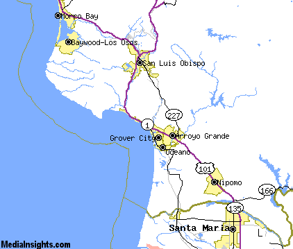
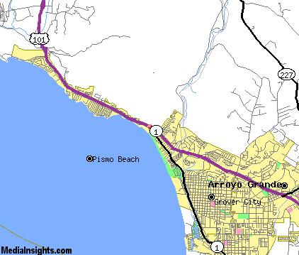
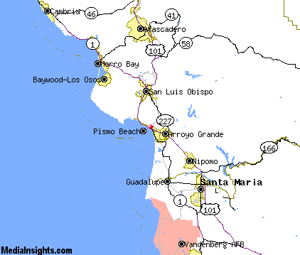
Pismo Beach Map & Transportation
|

|
|
 |
|
|
| Click each thumbnail image to enlarge. |
 |
|
 |
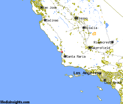 |
The closest airports in the area are the San Luis County Regional airport (SBP) located about 6 miles north of Pismo Beach in San Luis Obispo, California, the Santa Maria Pub Cpt G Allan Hancock airport (SMX) located approximately 20 miles southeast of Pismo Beach in Santa Maria, California, the Paso Robles Municipal airport (PRB) located roughly 36 miles north of Pismo Beach in Paso Robles, California, the Santa Barbara Municipal airport (SBA) located around 67 miles southeast of Pismo Beach in Santa Barbara, California, and finally the New Coalinga Municipal airport (C80) located about 72 miles northeast of Pismo Beach in Coalinga, California.
|

|
Pismo Beach Attractions
|

|
|
| | | Golf Courses |
| Pismo State Beach Golf Course | Grover Beach | CA | 1.8 mi. | | | Dairy Creek Golf Course | San Luis Obispo | CA | 8.8 mi. | | | Laguna Lake Golf Course | San Luis Obispo | CA | 8.8 mi. | | | Blacklake Golf Course | Nipomo | CA | 12.1 mi. | | | Morro Bay Golf Course | Morro Bay | CA | 19.7 mi. | | | Chalk Mountain Golf Course | Atascadero | CA | 22.3 mi. | | | Eagle Creek Golf Course | Atascadero | CA | 22.9 mi. | |
| | | State Parks |
| Montana de Oro State Park | | CA | 14.2 mi. | | | Point Sal Beach State Park | | CA | 17.2 mi. | | | Morro Bay State Park | | CA | 17.3 mi. | | | San Simeon Beach State Park | | CA | 40.0 mi. | |
| | | Museums |
| Hearst San Simeon State Historical Monument | San Simeon | CA | 45.9 mi. | (Art) |
| | | Zoos and Aquariums |
| Charles Paddock Zoo | Atascadero | CA | 23.6 mi. | | | Santa Barbara Zoological Gardens | Santa Barbara | CA | 73.8 mi. | |
Notice a problem with the information on this page? Please notify us.
|
Disclaimer: We recommend you conduct your own research regarding all accomodations and attractions found on this website. The distances shown on this website are straight-line distances as the crow flies. The road distance may be considerably longer. You assume all liability for use of any information found on this website. No information is confirmed or warranted in any way. By using our services you agree to the terms and conditions of this disclaimer.
|
| We are the #1 site for your California Vacation presenting California vacation rentals, hotels, weather and map for each city. |
California Vacation and Hawaiian Vacation are publications and trademarks of Media Insights, Inc.
©1997-2025 All Rights Reserved.
|
|