 |
Los-Alamos
is a small, historical town located in south central California, off Highway 101 between Santa Barbara and San Luis Obispo. This little community of 1,000 that was once a stagecoach stop, today has two beautiful Victorian hotels, restaurants, antiques shops and a winery. Los Alamos is Spanish for "the Cottonwoods" and was used to describe this town that is set along the Cottonwood lined San Antonio Creek. The Victorian mansion that now operates as a resort hotel has exotic theme rooms, including a 1950s room, Egyptian and Roman rooms, and is a perfect place for a fantasy "escape" weekend retreat. Another fantasy adventure includes the Los Alamos "Stagecoach Murder Mysteries." Once a month, guests are invited to dress in Old West costume and try to figure out "who dunnit" by talking with other partygoers. Winners are announced at the end of the night during dinner. Other special events in Los Alamos include a street festival in September, an annual Halloween Ball and a Civil War Christmas Ball. A nice side trip is to visit the winery located in Los Alamos which is open daily for free wine tasting and also has a picnic area. Los Alamos is definitely the kind of place to come and relax as you take a step back in time.
Surrounding areas: Solvang, California (12.8 mi), Santa Ynez, California (14.2 mi), Lompoc, California (19.1 mi), Jalama Beach, California (20.6 mi), Nipomo, California (23.3 mi), Oceano, California (31.4 mi), Arroyo Grande, California (32.6 mi)
|

|
Los Alamos Vacation Rentals
|

|
|
|
|
|
Los Alamos Hotels and Resorts
|
|
|
| | | Hotels & Motels |
| Days Inn | 114 E Hwy 246 | Buellton, CA | 10.1 mi. | (805) 688-8448 | | Rodeway Inn | 630 Ave Of The Flags | Buellton, CA | 10.1 mi. | (805) 688-0022 | | Santa Ynez Valley Marriott | 555 Mcmurry Rd | Buellton, CA | 10.1 mi. | (805) 688-1000 | | Motel 6 #062 | 333 Mcmurray Blvd | Buellton, CA | 10.2 mi. | (805) 688-7797 | | Los Olivos Grand Hotel | | Los Olivos, CA | 10.5 mi. | (805) 688-7788 | | White Oaks Hotel & Restaurant | 3955 Apollo Way | Lompoc, CA | 11.3 mi. | (805) 733-5000 | | The Ballard Inn | 2436 Baseline Ave | Ballard, CA | 11.7 mi. | (805) 688-7770 | | Motel 6 #1365 | 1521 N H St | Lompoc, CA | 11.7 mi. | (805) 735-7631 | | Quality Inn & Executive Suites | 1621 N H St | Lompoc, CA | 11.7 mi. | (805) 735-8555 | | Holiday Inn Express | 1417 North H St | Lompoc, CA | 11.8 mi. | (805) 736-2391 | | Travelodge Lompoc | 1415 E Ocean Ave | Lompoc, CA | 11.8 mi. | (805) 736-6514 | | Days Inn | 1122 N H St | Lompoc, CA | 11.9 mi. | (805) 735-7744 | | Embassy Suites Hotel | 1117 N H St | Lompoc, CA | 11.9 mi. | (805) 735-8311 | | Super 8 | 1020 E Ocean Ave | Lompoc, CA | 12.1 mi. | (805) 735-6444 | | Best Western Vandenberg Inn | 940 E Ocean Ave | Lompoc, CA | 12.2 mi. | (805) 735-7731 | | Holiday Inn Express - Solvang | 1455 Mission Dr | Solvang, CA | 12.5 mi. | (805) 688-2018 | | Viking Motel | 1506 MSN Dr | Solvang, CA | 12.8 mi. | (805) 688-1337 | | Solvang Royal Scandinavian Inn | 400 Alisal Rd | Solvang, CA | 12.9 mi. | (805) 688-8000 | | Travelodge | 1514 S Broadway | Santa Maria, CA | 16.1 mi. | (805) 922-2123 | | Comfort Inn | 210 Nicholson Ave | Santa Maria, CA | 16.6 mi. | (805) 922-5891 | | Santa Maria Inn | 801 S Broadway | Santa Maria, CA | 16.7 mi. | (805) 928-7777 | | Motel 6 #675 | 2040 N Preisler Ln | Santa Maria, CA | 17.2 mi. | (805) 928-8111 | | Radisson Hotel Santa Maria | 3455 Skwy Dr | Santa Maria, CA | 17.2 mi. | (805) 928-8000 | | Town Center Hotel | 215 N Broadway | Santa Maria, CA | 17.3 mi. | (805) 925-6163 | | Best Western Big America | 1725 N Broadway | Santa Maria, CA | 18.3 mi. | (805) 922-5200 | | Holiday In Hotel & Suites | 2100 N Broadway | Santa Maria, CA | 18.6 mi. | (805) 928-6000 |

|
Los Alamos Weather & Climate
|

|
|
|
The climate of the Los Alamos area is very similar to that of the central coast cities such as Santa Barbara. Although located slightly inland, the weather is influenced greatly by the Pacific Ocean. Temperatures are pleasant year round, although it is slightly warmer in summer and slightly cooler in winter than right along the coastline. The Los Alamos region gets over 300 days of sunshine per year and has very low humidity levels. The rainy season runs November through March, with only about 18 inches of rain per year. Low clouds from the ocean can drift into the area in summertime, but mostly skies are clear and sunny. Cooling ocean breezes help moderate the temperatures.
|
| Month |
High Temp |
Low Temp |
Rainfall |
Ocean Temp |
| January |
66°F |
41°F |
3.15 in. |
57°F |
| February |
67°F |
43°F |
3.89 in. |
57°F |
| March |
68°F |
44°F |
3.70 in. |
56°F |
| April |
70°F |
45°F |
1.08 in. |
57°F |
| May |
71°F |
48°F |
0.35 in. |
58°F |
| June |
73°F |
51°F |
0.07 in. |
59°F |
| July |
75°F |
53°F |
0.01 in. |
63°F |
| August |
76°F |
54°F |
0.04 in. |
64°F |
| September |
77°F |
53°F |
0.36 in. |
64°F |
| October |
76°F |
49°F |
0.59 in. |
62°F |
| November |
71°F |
44°F |
1.38 in. |
61°F |
| December |
66°F |
40°F |
2.30 in. |
58°F |

|
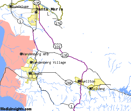
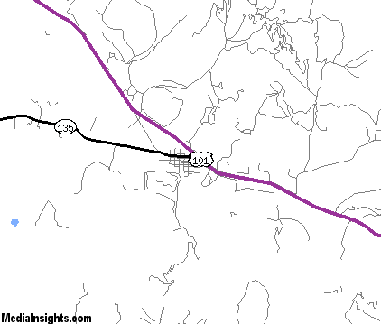
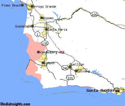
Los Alamos Map & Transportation
|

|
|
 |
|
|
| Click each thumbnail image to enlarge. |
 |
|
 |
 |
The closest airports in the area are the Santa Maria Pub Cpt G Allan Hancock airport (SMX) located about 14 miles northwest of Los Alamos in Santa Maria, California, the Santa Barbara Municipal airport (SBA) located approximately 32 miles southeast of Los Alamos in Santa Barbara, California, the Paso Robles Municipal airport (PRB) located roughly 67 miles northwest of Los Alamos in Paso Robles, California, and finally the Oxnard airport (OXR) located around 71 miles southeast of Los Alamos in Oxnard, California.
|

|
Los Alamos Attractions
|

|
|
| | | Water Parks |
| Six Flags Hurricane Harbor | Valencia | CA | 97.0 mi. | | | Six Flags Hurricane Harbor | Santa Clarita | CA | 101.6 mi. | |
| | | Golf Courses |
| Zaca Creek Golf Course | Buellton | CA | 10.2 mi. | | | La Purisima Golf Course | Lompoc | CA | 12.6 mi. | | | River Course at Alisal | Solvang | CA | 13.4 mi. | | | Blacklake Golf Course | Nipomo | CA | 23.3 mi. | |
| | | State Parks |
| Gaviota State Park | | CA | 19.1 mi. | | | Refugio Beach State Park | | CA | 22.7 mi. | | | Refugio Beach State park | | CA | 22.7 mi. | | | Point Sal Beach State Park | | CA | 23.4 mi. | | | El Capitan Beach State Park | | CA | 24.3 mi. | | | El Capitan Beach State Park | | CA | 24.6 mi. | | | Goleta Beach State Park | | CA | 34.6 mi. | |
| | | Museums |
| Santa Barbara Museum of Natural History | Santa Barbara | CA | 39.7 mi. | (Multidisciplinary) | | Santa Barbara Maritime Museum | Santa Barbara | CA | 39.7 mi. | (Science) | | Virtual Egyptian Museum - Padibastet's Tomb | Santa Barbara | CA | 39.7 mi. | (Art) |
| | | Zoos and Aquariums |
| Santa Barbara Zoological Gardens | Santa Barbara | CA | 39.7 mi. | | | Charles Paddock Zoo | Atascadero | CA | 56.3 mi. | |
Notice a problem with the information on this page? Please notify us.
|
Disclaimer: We recommend you conduct your own research regarding all accomodations and attractions found on this website. The distances shown on this website are straight-line distances as the crow flies. The road distance may be considerably longer. You assume all liability for use of any information found on this website. No information is confirmed or warranted in any way. By using our services you agree to the terms and conditions of this disclaimer.
|
| We are the #1 site for your California Vacation presenting California vacation rentals, hotels, weather and map for each city. |
California Vacation and Hawaiian Vacation are publications and trademarks of Media Insights, Inc.
©1997-2025 All Rights Reserved.
|
|