Surrounding areas: Loomis, California (8.5 mi), Georgetown, California (12.8 mi), Cold Springs, California (15.5 mi), Foresthill, California (16.2 mi), Placerville, California (18.9 mi), Grass Valley, California (22.2 mi), Lake Wildwood, California (24.2 mi)
|

|
Auburn Vacation Rentals
|

|
|
|
|
|
Auburn Hotels and Resorts
|
|
|
| | | Hotels & Motels |
| Best Western Golden Key Motel | 13450 Lincoln Way | Auburn, CA | | (530) 885-8611 | | Comfort Inn Central | 1875 Auburn Ravine Rd | Auburn, CA | | (530) 885-1800 | | Holiday Inn Auburn | 120 Grass Valley Hwy | Auburn, CA | | (530) 887-8787 | | Oakwood Worldwide At Shaliko | 5051 El Don Dr | Rocklin, CA | 10.7 mi. | (800) 483-1335 | | Days Inn Rocklin | 4515 Granite Dr | Rocklin, CA | 10.8 mi. | (916) 632-0101 | | First Choice Inns Hotel | 4420 Rocklin Rd | Rocklin, CA | 11.1 mi. | (916) 624-4500 | | Heritage Inn Express | 4480 Rocklin Rd | Rocklin, CA | 11.1 mi. | (916) 632-3366 | | Rocklin Park Hotel | 5450 China GDN Rd | Rocklin, CA | 11.4 mi. | (916) 630-9400 | | Oakwood Worldwide At Emerald Pointe | 101 Gold Cir | Rocklin, CA | 12.3 mi. | (800) 483-1335 | | Oakwood Worldwide At Rocklin Gold | 2651 Sunset Blvd | Rocklin, CA | 12.4 mi. | (800) 483-1335 | | Oakwood Worldwide At The Meridian | 2121 Sunset Blvd | Rocklin, CA | 12.5 mi. | (800) 483-1335 | | Sunset Summit Apartments | 2151 Sunset Blvd | Rocklin, CA | 12.5 mi. | (916) 624-9044 | | Comfort Suites | 6830 Five Star Blvd | Rocklin, CA | 13.0 mi. | (916) 315-1300 | | Hilton Garden Inn Roseville | 1951 Taylor Rd | Roseville, CA | 13.3 mi. | (916) 773-7171 | | Courtyard By Marriott | 1920 Taylor Rd | Roseville, CA | 13.4 mi. | (916) 772-9555 | | Fairfield Inn By Marriott | 1910 Taylor Rd | Roseville, CA | 13.4 mi. | (916) 772-3500 | | Larkspur Landing | 1931 Taylor Rd | Roseville, CA | 13.4 mi. | (916) 773-1717 | | Residence Inn | 1930 Taylor Rd | Roseville, CA | 13.4 mi. | (916) 772-5500 | | Slate Creek At Johnson Ranch | 1751 E Roseville Pkwy | Roseville, CA | 13.7 mi. | (916) 773-5525 | | Holiday Inn Express Hotel & Suites | 1398 E Roseville | Roseville, CA | 14.0 mi. | (916) 774-6060 | | Extended Stay America | 1000 Lead Hill Rd | Roseville, CA | 14.5 mi. | (916) 781-9001 | | Best Western Roseville Inn | 220 Harding Blvd | Roseville, CA | 14.7 mi. | (916) 782-4434 | | Oxford Suites | 130 N Sunrise Ave | Roseville, CA | 14.7 mi. | (916) 784-2222 | | Courtyard By Marriott II - Galleria Mall | 301 Creekside Ridge Ct | Roseville, CA | 15.3 mi. | (916) 772-3404 | | Homewood Suites Roseville Ca | 401 Creekside Ridge Ct | Roseville, CA | 15.3 mi. | (916) 783-7455 | | Pinnacle At Blue Ravine | 1005 Blue Ravine Rd | Folsom, CA | 15.7 mi. | (916) 984-8077 | | Lake Natoma Inn | 702 Gold Lake Dr | Folsom, CA | 16.2 mi. | (916) 351-1500 | | Oakwood Worldwide At Folsom Ranch | 1000 Folsom RNCH Dr | Folsom, CA | 16.2 mi. | (800) 483-1335 | | Oakwood Worldwide At Lake Ridge | 2400 Natoma Sta Dr | Folsom, CA | 16.2 mi. | (800) 483-1335 | | Overlook At Blue Ravine | 1200 Creekside Dr | Folsom, CA | 16.5 mi. | (916) 983-8338 | | Holiday Inn Express Hotel & Suites | 4360 Town Center Blvd | El Dorado Hills, CA | 17.2 mi. | (866) 833-8773 | | Folsom Courtyard | 2575 Iron Point Rd | Folsom, CA | 17.5 mi. | (916) 984-7624 | | Ashton Place | 885 Halidon Way | Folsom, CA | 17.6 mi. | (916) 984-8400 | | Residence Inn Sacramento Folsom | 2555 Iron Point Rd | Folsom, CA | 17.6 mi. | (916) 983-7289 | | Hilton Garden Inn Folsom | 221 Iron Point Rd | Folsom, CA | 18.7 mi. | (916) 353-1717 | | Larkspur Landing Home Suite Hotel | 121 Iron Point Rd | Folsom, CA | 18.7 mi. | (916) 355-1616 | | Best Western Placerville Inn | 6850 Greenleaf Dr | Placerville, CA | 18.9 mi. | (530) 622-9100 | | Olive Grove Suites | 6143 Auburn Blvd | Citrus Heights, CA | 20.2 mi. | (916) 725-0100 | | Cobble Oaks | 12155 Tributary Point Rd | Gold River, CA | 20.9 mi. | (916) 351-1133 | | Coach N' Four Motel | 628 S Auburn St | Grass Valley, CA | 21.4 mi. | (530) 273-8009 |

|
Auburn Weather & Climate
|

|
|
|
The foothills region of the Sierra Nevada Mountains, in Northeastern California, enjoys warm, dry summers and mild, wet winters. Many people are surprised to find such a marked change of seasons at this elevation, but leaves change and temperatures drop as the rainy season begins in fall. This area receives lots of rain November through March and it begins to taper off in spring. Summers are hot and dry with sunshine almost every day. Fog is sometimes a problem in winter, although not as common as in the lower elevations. Thunderstorms are rare, but can happen any time of the year. As you move higher into the Sierra Nevada Mountains, the seasons are even more distinct and snow can become quite deep in winter.
|
| Month |
High Temp |
Low Temp |
Rainfall |
Ocean Temp |
| January |
54°F |
37°F |
6.68 in. |
- |
| February |
58°F |
40°F |
6.28 in. |
- |
| March |
61°F |
42°F |
6.16 in. |
- |
| April |
67°F |
45°F |
2.50 in. |
- |
| May |
75°F |
50°F |
1.30 in. |
- |
| June |
84°F |
57°F |
0.37 in. |
- |
| July |
91°F |
62°F |
0.14 in. |
- |
| August |
90°F |
62°F |
0.14 in. |
- |
| September |
85°F |
58°F |
0.77 in. |
- |
| October |
75°F |
52°F |
1.93 in. |
- |
| November |
61°F |
43°F |
4.89 in. |
- |
| December |
54°F |
37°F |
5.35 in. |
- |

|
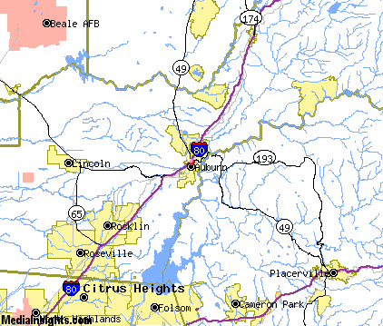
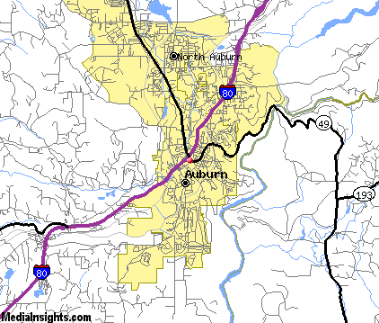
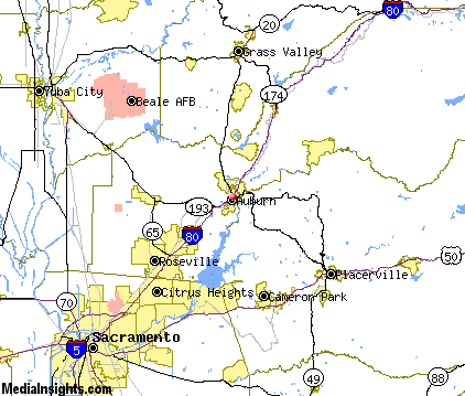
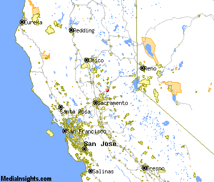
Auburn Map & Transportation
|

|
|
 |
|
|
| Click each thumbnail image to enlarge. |
 |
|
 |
 |
The closest airports in the area are Lincoln Regional Karl Harder Field (LHM) located about 14 miles west of Auburn in Lincoln, California, the Mc Clellan Airfield (MCC) located approximately 23 miles southwest of Auburn in Sacramento, California, the Sacramento Mather airport (MHR) located roughly 26 miles southwest of Auburn in Sacramento, California, and finally the Yuba County airport (MYV) located around 29 miles northwest of Auburn in Marysville, California.
|

|
Auburn Attractions
|

|
|
| | | Amusement and Theme Parks |
| Funderland | Sacramento | CA | 31.5 mi. | | | Funderwoods | Lodi | CA | 54.1 mi. | | | Tahoe Amusement Park | South Lake Tahoe | CA | 58.7 mi. | | | Playland Park | Reno | NV | 80.4 mi. | | | Pixieland Park | Concord | CA | 82.0 mi. | | | Wild Island | Sparks | NV | 83.3 mi. | | | Six Flags Marine World | Vallejo | CA | 84.2 mi. | | | Traintown | Sonoma | CA | 85.6 mi. | |
| | | Water Parks |
| Waterworld USA | Sacramento | CA | 31.5 mi. | | | Waterworld USA | Concord | CA | 82.0 mi. | | | Wild Island Family Adventure Park | Sparks | NV | 83.3 mi. | | | Big Bear Park | Waterford | CA | 88.5 mi. | | | Raging Waters | San Jose | CA | 116.6 mi. | |
| | | Golf Courses |
| Black Oak Golf Course | Auburn | CA | | | | Course at Raspberry Hill | Auburn | CA | | | | DarkHorse | Auburn | CA | | | | DarkHorse Golf Club | Auburn | CA | | | | Ridge Golf Course | Auburn | CA | | | | Indian Creek Country Club | Loomis | CA | 9.0 mi. | | | Whitney Oaks Golf Club | Rocklin | CA | 11.3 mi. | | | Catta Verdera Golf Club | Lincoln | CA | 11.6 mi. | | | Lincoln Hills Club | Lincoln | CA | 11.6 mi. | | | Turkey Creek Golf Club | Lincoln | CA | 11.6 mi. | | | Diamond Oaks Municipal Golf Course | Roseville | CA | 14.4 mi. | | | El Dorado Hills Golf Course | El Dorado Hills | CA | 16.5 mi. | | | Empire Ranch Golf Club | Folsom | CA | 16.6 mi. | | | Folsom Lake Golf Course | Folsom | CA | 16.6 mi. | | | Sierra Golf Course | Placerville | CA | 18.9 mi. | | | Antelope Greens Golf Course | Antelope | CA | 19.1 mi. | | | Foothill Golf Center | Sacramento | CA | 19.6 mi. | | | Lawrence Links Golf Course | Antelope | CA | 21.0 mi. | | | Alta Sierra Country Club | Grass Valley | CA | 22.2 mi. | | | Cherry Island Golf Course | Elverta | CA | 22.2 mi. | | | Nevada County Country Club | Grass Valley | CA | 22.2 mi. | | | Ancil Hoffman Golf Course | Carmichael | CA | 23.9 mi. | | | Apple Mountain Golf Resort | Camino | CA | 24.7 mi. | | | Haggin Oaks Golf Course | Sacramento | CA | 25.5 mi. | | | Rio La Paz Golf Club | Nicolaus | CA | 26.6 mi. | | | Cordova Golf Course | Sacramento | CA | 29.0 mi. | | | Campus Commons Golf Course | Sacramento | CA | 29.2 mi. | |
| | | Ski Areas |
| Donner Ski Ranch | Norden | CA | 48.3 mi. | | | Sugar Bowl Tahoe | Norden | CA | 48.3 mi. | | | Ski Homewood | Homewood | CA | 50.9 mi. | | | Squaw Valley | Olympic Valley | CA | 50.9 mi. | | | Sierra-at-Tahoe | Twin Bridges | CA | 51.5 mi. | | | Alpine Meadows | Tahoe City | CA | 53.7 mi. | | | Kirkwood Ski Resort | Kirkwood | CA | 55.7 mi. | | | Northstar-at-Tahoe | Truckee | CA | 56.3 mi. | | | Tahoe Donner | Truckee | CA | 56.3 mi. | | | Heavenly Ski Resort | South Lake Tahoe | CA | 58.9 mi. | | | Bear Valley | Bear Valley | CA | 63.4 mi. | | | Diamond Peak | Incline Village | NV | 64.0 mi. | | | Dodge Ridge | Pinecrest | CA | 78.7 mi. | | | Mount Rose Ski Area | Reno | NV | 80.4 mi. | |
| | | State Parks |
| Gold Discovery Site State Park | | CA | 12.0 mi. | | | Mormon Island Wetlands State Park | | CA | 14.6 mi. | | | Negro Bar State Park | | CA | 16.8 mi. | |
| | | Museums |
| Crocker Art Museum | Sacramento | CA | 31.5 mi. | (Art) | | Golden State Museum | Sacramento | CA | 31.5 mi. | (History) | | Emigrant Trail Museum | Truckee | CA | 56.3 mi. | (History) |
| | | Zoos and Aquariums |
| Sacramento Zoo | Sacramento | CA | 31.5 mi. | | | Micke Grove Zoo | Lodi | CA | 54.1 mi. | | | Six Flags Marine World | Vallejo | CA | 84.2 mi. | | | The Oakland Zoo | Oakland | CA | 99.6 mi. | | | San Francisco Zoological Gardens | San Francisco | CA | 106.5 mi. | | | Steinhart Aquarium | San Francisco | CA | 106.5 mi. | | | Happy Hollow Park and Zoo | San Jose | CA | 116.6 mi. | |
Notice a problem with the information on this page? Please notify us.
|
Disclaimer: We recommend you conduct your own research regarding all accomodations and attractions found on this website. The distances shown on this website are straight-line distances as the crow flies. The road distance may be considerably longer. You assume all liability for use of any information found on this website. No information is confirmed or warranted in any way. By using our services you agree to the terms and conditions of this disclaimer.
|
| We are the #1 site for your California Vacation presenting California vacation rentals, hotels, weather and map for each city. |
California Vacation and Hawaiian Vacation are publications and trademarks of Media Insights, Inc.
©1997-2025 All Rights Reserved.
|
|