 |
Shingletown
is located 30 miles east of Redding and only 19 miles from the entrance to Lassen National Park. This small mountain community of approximately 10,000 is in the middle of one of the most beautiful and unspoiled regions in the state of California. Surrounded by state forests, meandering creeks and streams, small lakes and meadows, Shingletown offers visitors a respite from busy city life. Outdoors recreation is important to Shingletown, especially fly-fishing, which attracts visitors from all over the country. Lakes Grace and Nora, Hat Creek, Battlecreek Reservoir and McCumber Lake all offer excellent fishing opportunities. Other popular sports in the area include boating, hiking, mountain biking, and skiing. Nearby Lassen National Park and Mount Shasta offer lots of sightseeing opportunities and other attractions in the area include Burney Falls, Wild Horse Sanctuary and Subway Caves. There are several fine restaurants in Shingletown and lodging ranges from comfortable hotels and bed and breakfasts, luxury vacation homes to rustic cabins and campsites. With a serene setting in the foothills of Mt. Lassen, Shingletown makes a convenient and picturesque base for your northern California vacation.

|
Shingletown Vacation Rentals
|

|
|
|
|
|
Shingletown Hotels and Resorts
|
|
|
| | | Hotels & Motels |
| Amerihost Inn | 2040 Deschutes Rd | Anderson, CA | 20.0 mi. | (530) 365-6100 | | Best Western Knights Inn | 2688 Gtwy Dr | Anderson, CA | 23.0 mi. | (530) 365-2753 | | Hilton Garden Inn | 5050 Bechelli Ln | Redding, CA | 25.9 mi. | (530) 226-5111 | | Amerihost Inn & Suites | 2600 Larkspur Ln | Redding, CA | 26.3 mi. | (530) 722-9100 | | Grand Manor Inn | 850 Mistletoe Ln | Redding, CA | 26.4 mi. | (530) 221-4472 | | Hampton Inn & Suites | 2160 Larkspur Ln | Redding, CA | 26.4 mi. | (530) 224-1001 | | Best Western Hilltop Inn | 2300 Hilltop Dr | Redding, CA | 26.5 mi. | (800) 336-4880 | | Days Hotel | 2180 Hilltop Dr | Redding, CA | 26.5 mi. | (530) 221-8200 | | La Quinta Inn-redding | 2180 Hilltop Dr | Redding, CA | 26.5 mi. | (530) 221-8200 | | Holiday Inn Convention Center | 1900 Hilltop Dr | Redding, CA | 26.6 mi. | (800) 626-1900 | | Howard Johnson Express Inn | 2731 Bechelli Ln | Redding, CA | 26.6 mi. | (530) 223-1935 | | Meyer Motels LTD | 2051 Hilltop Dr | Redding, CA | 26.6 mi. | (530) 221-8250 | | Motel 6 #95 | 1640 Hilltop Dr | Redding, CA | 26.6 mi. | (530) 221-1800 | | Oxford Suites | 1967 Hilltop Dr | Redding, CA | 26.6 mi. | (530) 221-0100 | | Quality Inn | 2059 Hilltop Dr | Redding, CA | 26.6 mi. | (530) 221-6530 | | Red Lion Hotel-Redding | 1830 Hilltop Dr | Redding, CA | 26.6 mi. | (530) 221-8700 | | Motel 6 #1371 | 2385 Bechelli Ln | Redding, CA | 26.7 mi. | (530) 221-0562 | | Ramada Limited | 1286 Twin View Blvd | Redding, CA | 27.8 mi. | (530) 246-2222 | | Best Western Ponderosa Inn | 2220 Pine St | Redding, CA | 28.0 mi. | (530) 241-6300 | | Redding Travelodge | 540 N Market St | Redding, CA | 28.3 mi. | (530) 243-5291 | | Rodeway Inn | 532 N Market St | Redding, CA | 28.3 mi. | (530) 241-6464 | | Econo Lodge | 2010 Pne St | Redding, CA | 28.4 mi. | (530) 243-3336 | | Holiday Inn Express | 1080 Twin VW Blvd | Redding, CA | 28.4 mi. | (530) 241-5500 | | Motel 6 #674 | 1250 Twin VW Blvd | Redding, CA | 28.4 mi. | (530) 246-4470 | | Super 8 Motel | 5175 Churn CRK Rd | Redding, CA | 28.4 mi. | (530) 221-8881 | | Motel 6 | 20 Williams Ave | Red Bluff, CA | 28.6 mi. | (530) 527-9200 | | Best Western Antelope Inn | 203 Antelope Blvd | Red Bluff, CA | 28.7 mi. | (530) 527-8882 | | Comfort Inn | 90 Sale Ln | Red Bluff, CA | 28.7 mi. | (530) 529-7077 | | Super 8 | 30 Gilmore Rd | Red Bluff, CA | 29.1 mi. | (530) 529-2028 | | Shasta Pines Motel | 37386 Main St | Burney, CA | 29.2 mi. | (530) 335-2201 | | Lamplighter Lodge | 210 S Main St | Red Bluff, CA | 29.6 mi. | (530) 527-1150 | | American Inn Express | 250 S Main St | Red Bluff, CA | 29.7 mi. | (530) 527-3545 |

|
Shingletown Weather & Climate
|

|
|
|
North Central California , near the town of Redding, has hot, dry summers and cool, moist winters. Located near Mount Shasta/Mount Lassen and the Shasta Trinity National Forest, this region's climate varies greatly according to elevation. There is little to no humidity in the summertime and temperatures at the lower elevations sometimes climb above the 100-degree mark. Higher elevations tend to have much cooler temperatures and higher precipitation in summer. Fall days are mild with cool nights. Winter is the rainy season, with an average of 55 inches of rain per year in the lower elevations and snow in the higher elevations. Spring weather can be unstable with cool periods of rain or mild, sunny days. The 10,457-foot Lassen Peak crowns Lassen Volcanic National Park. The last volcanic activity at Mount Lassen was in 1915.
|
| Month |
High Temp |
Low Temp |
Rainfall |
Ocean Temp |
| January |
41°F |
21°F |
7.05 in. |
- |
| February |
42°F |
21°F |
7.05 in. |
- |
| March |
45°F |
24°F |
7.76 in. |
- |
| April |
51°F |
27°F |
3.81 in. |
- |
| May |
60°F |
34°F |
2.75 in. |
- |
| June |
70°F |
40°F |
1.10 in. |
- |
| July |
78°F |
44°F |
0.23 in. |
- |
| August |
77°F |
43°F |
0.46 in. |
- |
| September |
71°F |
39°F |
1.32 in. |
- |
| October |
60°F |
33°F |
3.02 in. |
- |
| November |
46°F |
25°F |
5.77 in. |
- |
| December |
41°F |
21°F |
6.32 in. |
- |

|
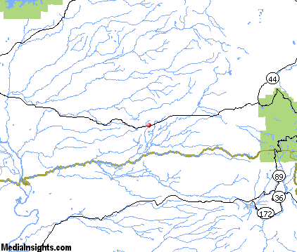
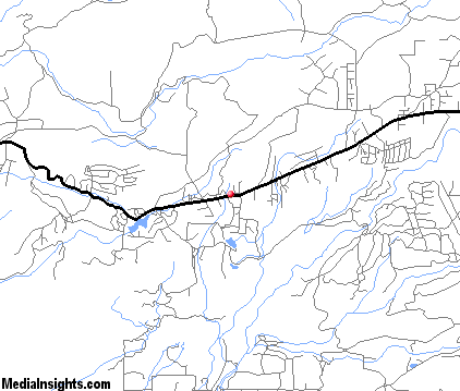
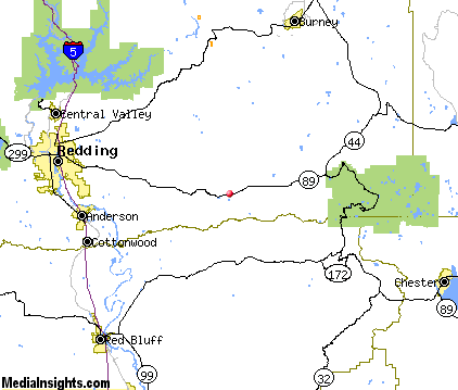
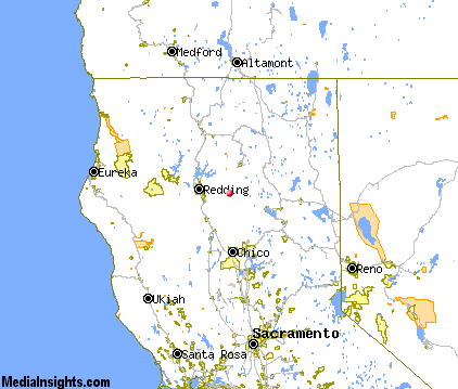
Shingletown Map & Transportation
|

|
|
 |
|
|
| Click each thumbnail image to enlarge. |
 |
|
 |
 |
The closest airports in the area are the Redding Municipal airport (RDD) located about 22 miles west of Shingletown in Redding, California, the Red Bluff Municipal airport (RBL) located approximately 31 miles southwest of Shingletown in Red Bluff, California, the Chico Municipal airport (CIC) located roughly 48 miles south of Shingletown in Chico, California, and finally the Oroville Municipal airport (OVE) located around 70 miles south of Shingletown in Oroville, California.
|

|
Shingletown Attractions
|

|
|
| | | Water Parks |
| Waterworks Park | Redding | CA | 28.4 mi. | |
| | | Golf Courses |
| Palo Cedro Golf Club | Palo Cedro | CA | 19.7 mi. | | | Churn Creek Golf Course | Redding | CA | 23.9 mi. | | | Gold Hills Country Club | Redding | CA | 27.0 mi. | | | Allens Golf Course | Redding | CA | 27.2 mi. | | | Anderson Tucker Oaks Golf Course | Redding | CA | 27.2 mi. | | | River Bend Golf & Country Club | Redding | CA | 27.2 mi. | | | Lake Redding Golf Course | Redding | CA | 28.9 mi. | |
| | | Ski Areas |
| Mount Shasta Ski Park | Shasta | CA | 33.7 mi. | | | Donner Ski Ranch | Norden | CA | 114.1 mi. | | | Sugar Bowl Tahoe | Norden | CA | 114.1 mi. | |
| | | State Parks |
| McArthur-Burney Falls Memorial State Park | | CA | 37.2 mi. | |
| | | Museums |
| Herb Lane Museum | Redding | CA | 28.4 mi. | (Art) | | Redding Museum of Art and History | Redding | CA | 28.4 mi. | (Art) | | Tehama County Museum | Tehama | CA | 35.1 mi. | (History) | | UCLA Fowler Museum of Cultural History | Westwood | CA | 47.1 mi. | (History) |
Notice a problem with the information on this page? Please notify us.
|
Disclaimer: We recommend you conduct your own research regarding all accomodations and attractions found on this website. The distances shown on this website are straight-line distances as the crow flies. The road distance may be considerably longer. You assume all liability for use of any information found on this website. No information is confirmed or warranted in any way. By using our services you agree to the terms and conditions of this disclaimer.
|
| We are the #1 site for your California Vacation presenting California vacation rentals, hotels, weather and map for each city. |
California Vacation and Hawaiian Vacation are publications and trademarks of Media Insights, Inc.
©1997-2025 All Rights Reserved.
|
|