 |
Mount-Lassen
rises approximately 10,500 feet above sea level and towers above the region's seven national forests. Situated on the southern tip of the Cascade Mountains, Mount Lassen is an active, although "sleeping" volcano that last erupted in 1915. Mount Lassen is less visited than other popular California attractions and travel is restricted in wintertime, due to heavy snowfalls. But, Mount Lassen is one of the most unusual and fascinating places in the state. This impressive mountainous region has mud pools, gas vents, and hot springs, together with beautiful lakes, clear mountain streams, meadows, cliffs and waterfalls. Some of the most impressive things to see in the area include Manzinita Lake, the Lava Beds National Monument, Mill Creek Falls, and Lake Helen, located at the foot of Lassen Peak. Bumpass Hell is the largest area of geothermal features in Lassen National Park and is definitely a highlight of the park. A 1.5 mile trail from the parking lot opposite Lake Helen takes you to Bumpass Hell, where you can view sulfur pits, steaming mud pits, hot springs and noisy steam vents. Lassen State Park has lots of winter ski activities, and also has a lodge and camping available in the park. The nearby towns of Mt. Shasta, Dunsmuir, Burney, and McCloud offer more lodging and dining choices.

|
Mount Lassen Vacation Rentals
|

|
|
|
|
|
Mount Lassen Hotels and Resorts
|
|
|
| | | Hotels & Motels |
| Comfort Inn | 90 Sale Ln | Red Bluff, CA | 16.0 mi. | (530) 529-7077 | | Motel 6 | 20 Williams Ave | Red Bluff, CA | 16.0 mi. | (530) 527-9200 | | Best Western Antelope Inn | 203 Antelope Blvd | Red Bluff, CA | 16.1 mi. | (530) 527-8882 | | Super 8 | 30 Gilmore Rd | Red Bluff, CA | 16.5 mi. | (530) 529-2028 | | Lamplighter Lodge | 210 S Main St | Red Bluff, CA | 16.9 mi. | (530) 527-1150 | | American Inn Express | 250 S Main St | Red Bluff, CA | 17.0 mi. | (530) 527-3545 | | Days Inn Red Bluff | 5 Sutter St | Red Bluff, CA | 17.3 mi. | (530) 527-6130 | | Amerihost Inn | 2040 Deschutes Rd | Anderson, CA | 17.8 mi. | (530) 365-6100 | | Best Western Knights Inn | 2688 Gtwy Dr | Anderson, CA | 19.4 mi. | (530) 365-2753 | | Hilton Garden Inn | 5050 Bechelli Ln | Redding, CA | 25.3 mi. | (530) 226-5111 | | Amerihost Inn & Suites | 2600 Larkspur Ln | Redding, CA | 26.8 mi. | (530) 722-9100 | | Howard Johnson Express Inn | 2731 Bechelli Ln | Redding, CA | 26.9 mi. | (530) 223-1935 | | Best Western Hilltop Inn | 2300 Hilltop Dr | Redding, CA | 27.1 mi. | (800) 336-4880 | | Hampton Inn & Suites | 2160 Larkspur Ln | Redding, CA | 27.1 mi. | (530) 224-1001 | | Days Hotel | 2180 Hilltop Dr | Redding, CA | 27.2 mi. | (530) 221-8200 | | Grand Manor Inn | 850 Mistletoe Ln | Redding, CA | 27.2 mi. | (530) 221-4472 | | La Quinta Inn-redding | 2180 Hilltop Dr | Redding, CA | 27.2 mi. | (530) 221-8200 | | Motel 6 #1371 | 2385 Bechelli Ln | Redding, CA | 27.2 mi. | (530) 221-0562 | | Quality Inn | 2059 Hilltop Dr | Redding, CA | 27.2 mi. | (530) 221-6530 | | Holiday Inn Convention Center | 1900 Hilltop Dr | Redding, CA | 27.3 mi. | (800) 626-1900 | | Meyer Motels LTD | 2051 Hilltop Dr | Redding, CA | 27.3 mi. | (530) 221-8250 | | Oxford Suites | 1967 Hilltop Dr | Redding, CA | 27.3 mi. | (530) 221-0100 | | Red Lion Hotel-Redding | 1830 Hilltop Dr | Redding, CA | 27.4 mi. | (530) 221-8700 | | Motel 6 #95 | 1640 Hilltop Dr | Redding, CA | 27.5 mi. | (530) 221-1800 | | Best Western Ponderosa Inn | 2220 Pine St | Redding, CA | 28.4 mi. | (530) 241-6300 | | Comfort Inn | 910 Hwy 99 W | Corning, CA | 28.9 mi. | (530) 824-5200 | | Days Inn-corning | 3475 State Hwy 99 W | Corning, CA | 28.9 mi. | (530) 824-2000 | | Econo Lodge | 2010 Pne St | Redding, CA | 28.9 mi. | (530) 243-3336 | | Holiday Inn Express | 1080 Twin VW Blvd | Redding, CA | 28.9 mi. | (530) 241-5500 | | Motel 6 #674 | 1250 Twin VW Blvd | Redding, CA | 28.9 mi. | (530) 246-4470 | | Super 8 Motel | 5175 Churn CRK Rd | Redding, CA | 28.9 mi. | (530) 221-8881 | | Best Western Inn-corning | 2165 Solano St | Corning, CA | 29.3 mi. | (530) 824-2468 | | Redding Travelodge | 540 N Market St | Redding, CA | 29.3 mi. | (530) 243-5291 | | Rodeway Inn | 532 N Market St | Redding, CA | 29.3 mi. | (530) 241-6464 | | Ramada Limited | 1286 Twin View Blvd | Redding, CA | 29.8 mi. | (530) 246-2222 |

|
Mount Lassen Weather & Climate
|

|
|
|
North Central California , near the town of Redding, has hot, dry summers and cool, moist winters. Located near Mount Shasta/Mount Lassen and the Shasta Trinity National Forest, this region's climate varies greatly according to elevation. There is little to no humidity in the summertime and temperatures at the lower elevations sometimes climb above the 100-degree mark. Higher elevations tend to have much cooler temperatures and higher precipitation in summer. Fall days are mild with cool nights. Winter is the rainy season, with an average of 55 inches of rain per year in the lower elevations and snow in the higher elevations. Spring weather can be unstable with cool periods of rain or mild, sunny days. The 10,457-foot Lassen Peak crowns Lassen Volcanic National Park. The last volcanic activity at Mount Lassen was in 1915.
|
| Month |
High Temp |
Low Temp |
Rainfall |
Ocean Temp |
| January |
55°F |
37°F |
5.33 in. |
- |
| February |
60°F |
40°F |
4.79 in. |
- |
| March |
64°F |
43°F |
4.89 in. |
- |
| April |
71°F |
47°F |
2.76 in. |
- |
| May |
81°F |
54°F |
1.01 in. |
- |
| June |
90°F |
61°F |
0.42 in. |
- |
| July |
97°F |
65°F |
0.10 in. |
- |
| August |
96°F |
63°F |
0.24 in. |
- |
| September |
90°F |
59°F |
0.76 in. |
- |
| October |
79°F |
51°F |
1.81 in. |
- |
| November |
63°F |
42°F |
3.87 in. |
- |
| December |
55°F |
37°F |
4.74 in. |
- |

|
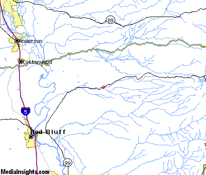
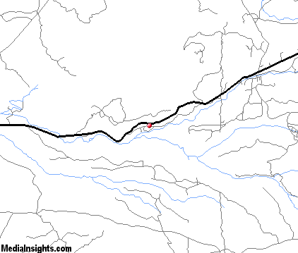
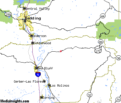
Mount Lassen Map & Transportation
|

|
|
 |
|
|
| Click each thumbnail image to enlarge. |
 |
|
 |
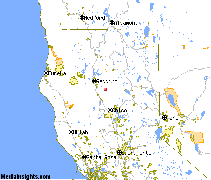 |
The closest airports in the area are the Red Bluff Municipal airport (RBL) located about 18 miles southwest of Mount Lassen in Red Bluff, California, the Redding Municipal airport (RDD) located approximately 21 miles northwest of Mount Lassen in Redding, California, the Chico Municipal airport (CIC) located roughly 36 miles south of Mount Lassen in Chico, California, and finally the Oroville Municipal airport (OVE) located around 60 miles south of Mount Lassen in Oroville, California.
|

|
Mount Lassen Attractions
|

|
|
| | | Water Parks |
| Waterworks Park | Redding | CA | 28.9 mi. | |
| | | Golf Courses |
| Oak Creek Golf Course | Red Bluff | CA | 17.8 mi. | | | Palo Cedro Golf Club | Palo Cedro | CA | 21.7 mi. | | | Churn Creek Golf Course | Redding | CA | 22.6 mi. | | | Allens Golf Course | Redding | CA | 27.7 mi. | | | Anderson Tucker Oaks Golf Course | Redding | CA | 27.7 mi. | | | River Bend Golf & Country Club | Redding | CA | 27.7 mi. | | | Gold Hills Country Club | Redding | CA | 29.6 mi. | | | Lake Redding Golf Course | Redding | CA | 29.8 mi. | |
| | | Ski Areas |
| Mount Shasta Ski Park | Shasta | CA | 33.6 mi. | | | Donner Ski Ranch | Norden | CA | 110.0 mi. | | | Sugar Bowl Tahoe | Norden | CA | 110.0 mi. | | | Northstar-at-Tahoe | Truckee | CA | 116.9 mi. | | | Tahoe Donner | Truckee | CA | 116.9 mi. | |
| | | Museums |
| Tehama County Museum | Tehama | CA | 21.4 mi. | (History) | | Herb Lane Museum | Redding | CA | 28.9 mi. | (Art) | | Redding Museum of Art and History | Redding | CA | 28.9 mi. | (Art) | | UCLA Fowler Museum of Cultural History | Westwood | CA | 50.9 mi. | (History) |
| | | Zoos and Aquariums |
| Sequoia Park Zoo | Eureka | CA | 119.9 mi. | |
Notice a problem with the information on this page? Please notify us.
|
Disclaimer: We recommend you conduct your own research regarding all accomodations and attractions found on this website. The distances shown on this website are straight-line distances as the crow flies. The road distance may be considerably longer. You assume all liability for use of any information found on this website. No information is confirmed or warranted in any way. By using our services you agree to the terms and conditions of this disclaimer.
|
| We are the #1 site for your California Vacation presenting California vacation rentals, hotels, weather and map for each city. |
California Vacation and Hawaiian Vacation are publications and trademarks of Media Insights, Inc.
©1997-2024 All Rights Reserved.
|
|