Surrounding areas: Graeagle, California (13.7 mi), Tahoe Donner, California (24.3 mi), Baxter, California (25.6 mi), Donner Lake, California (25.8 mi), Alta, California (26.6 mi), Truckee, California (29.1 mi), Nevada City, California (29.4 mi)
|

|
Sierra City Vacation Rentals
|

|
|
|
|
|
Sierra City Hotels and Resorts
|
|
|
| | | Hotels & Motels |
| Sleepy Pines Motel | 74631 State Rt 70 | Portola, CA | 19.0 mi. | (530) 832-4291 | | Loch Leven Lodge | 13855 Donner Pass Rd | Truckee, CA | 26.0 mi. | (530) 587-3773 | | Truckee Super 8 Lodge | 11506 Deerfield Dr | Truckee, CA | 28.1 mi. | (530) 587-8888 | | Best Western Trailside Inn | 343 N Main | Alturas, CA | 29.0 mi. | (530) 233-4111 | | Best Western Truckee Tahoe Inn | 11331 Hwy 267 | Truckee, CA | 29.1 mi. | (800) 824-6385 | | Hampton Inn & Suites Tahoe/Truckee | 11951 State Hwy #267 | Truckee, CA | 29.1 mi. | (530) 587-1197 | | Holiday Inn Express | 10527 Cold STRM Rd | Truckee, CA | 29.1 mi. | (530) 582-1073 | | Northern Queen Inn | 400 Railroad Ave | Nevada City, CA | 29.6 mi. | (530) 265-5824 |

|
Sierra City Weather & Climate
|

|
|
|
Northeastern California , where the Sierra Nevada and Cascade Mountain Ranges meet, has a four season climate, with cold, alpine mountain winters and mild summers. Many of the mountain communities, including Graeagle, Truckee and Donner Lake, experience what is called an "inversion," whereby cold air is trapped overnight by the mountain peaks, thus the reason for the extreme cold temperatures in the very early morning hours (even in summertime.) However, as the sun rises, the temperature climbs and daytime highs are usually quite pleasant. Large amounts of snow are received in the higher elevations of the Sierras - up to 40 feet. Rain is possible any month of the year, although most occurs October through April. Mountain weather conditions can change quickly, and visitors should remember that rain in the lower elevations can mean snow, sleet or ice in the higher elevations.
|
| Month |
High Temp |
Low Temp |
Rainfall |
Ocean Temp |
| January |
48°F |
29°F |
11.49 in. |
- |
| February |
50°F |
29°F |
12.00 in. |
- |
| March |
53°F |
31°F |
10.11 in. |
- |
| April |
60°F |
35°F |
4.41 in. |
- |
| May |
68°F |
40°F |
3.18 in. |
- |
| June |
77°F |
47°F |
1.00 in. |
- |
| July |
85°F |
52°F |
0.39 in. |
- |
| August |
85°F |
51°F |
0.55 in. |
- |
| September |
79°F |
47°F |
1.65 in. |
- |
| October |
69°F |
41°F |
3.99 in. |
- |
| November |
54°F |
32°F |
8.54 in. |
- |
| December |
48°F |
29°F |
8.98 in. |
- |

|
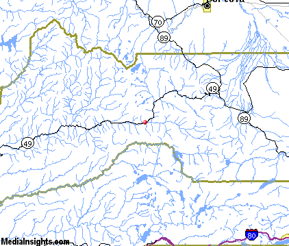
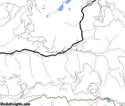
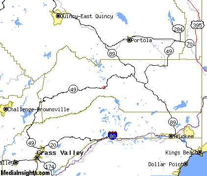
Sierra City Map & Transportation
|

|
|
 |
|
|
| Click each thumbnail image to enlarge. |
 |
|
 |
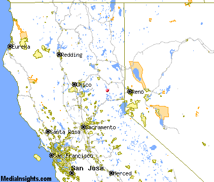 |
The closest airports in the area are the Reno Stead airport (4SD) located about 40 miles east of Sierra City in Reno, Nevada, the Reno Tahoe International airport (RNO) located approximately 46 miles east of Sierra City in Reno, Nevada, the Lake Tahoe airport (TVL) located roughly 57 miles southeast of Sierra City in South Lake Tahoe, California, and finally the Mc Clellan Airfield (MCC) located around 74 miles southwest of Sierra City in Sacramento, California.
|

|
Sierra City Attractions
|

|
|
| | | Amusement and Theme Parks |
| Playland Park | Reno | NV | 43.8 mi. | | | Wild Island | Sparks | NV | 47.0 mi. | | | Tahoe Amusement Park | South Lake Tahoe | CA | 55.8 mi. | | | Funderland | Sacramento | CA | 82.2 mi. | |
| | | Water Parks |
| Wild Island Family Adventure Park | Sparks | NV | 47.0 mi. | | | Waterworld USA | Sacramento | CA | 82.2 mi. | | | Waterworks Park | Redding | CA | 116.7 mi. | |
| | | Golf Courses |
| Graeagle Meadows Golf Course | Graeagle | CA | 13.7 mi. | | | Plumas Pines Golf Resort | Graeagle | CA | 13.7 mi. | | | Coyote Moon Golf Club | Truckee | CA | 29.1 mi. | | | Tahoe Donner Golf Club | Truckee | CA | 29.1 mi. | |
| | | Ski Areas |
| Donner Ski Ranch | Norden | CA | 22.6 mi. | | | Sugar Bowl Tahoe | Norden | CA | 22.6 mi. | | | Northstar-at-Tahoe | Truckee | CA | 29.1 mi. | | | Tahoe Donner | Truckee | CA | 29.1 mi. | | | Squaw Valley | Olympic Valley | CA | 35.7 mi. | | | Alpine Meadows | Tahoe City | CA | 37.9 mi. | | | Diamond Peak | Incline Village | NV | 41.4 mi. | | | Ski Homewood | Homewood | CA | 41.7 mi. | | | Mount Rose Ski Area | Reno | NV | 43.8 mi. | | | Heavenly Ski Resort | South Lake Tahoe | CA | 56.1 mi. | | | Sierra-at-Tahoe | Twin Bridges | CA | 58.9 mi. | | | Kirkwood Ski Resort | Kirkwood | CA | 66.8 mi. | | | Bear Valley | Bear Valley | CA | 82.5 mi. | | | Dodge Ridge | Pinecrest | CA | 96.5 mi. | |
| | | State Parks |
| Plumas Eureka State Park | | CA | 13.9 mi. | | | Donner Memorial State Park | | CA | 27.0 mi. | | | Burton Creek State Park | | CA | 37.0 mi. | | | Tahoe State Park | | CA | 38.3 mi. | |
| | | Museums |
| Portola Railroad Museum | Portola | CA | 19.0 mi. | (Technology) | | Emigrant Trail Museum | Truckee | CA | 29.1 mi. | (History) | | W.M. Keck Museum | Reno | NV | 43.8 mi. | (History) | | Nevada Historical Society | Reno | NV | 43.8 mi. | (Miscellaneous) | | Fleischmann Planetarium | Reno | NV | 43.8 mi. | (Science) | | National Automobile Museum | Reno | NV | 43.8 mi. | (Technology) | | Nevada Museum of Art | Reno | NV | 43.8 mi. | (Art) | | Stewart Indian Museum | Carson City | NV | 54.0 mi. | (History) | | Nevada State Railroad Museum | Carson City | NV | 54.0 mi. | (Technology) | | UCLA Fowler Museum of Cultural History | Westwood | CA | 54.8 mi. | (History) | | Genoa Courthouse Museum | Genoa | NV | 57.2 mi. | (History) |
| | | Zoos and Aquariums |
| Sacramento Zoo | Sacramento | CA | 82.2 mi. | | | Micke Grove Zoo | Lodi | CA | 105.0 mi. | |
Notice a problem with the information on this page? Please notify us.
|
Disclaimer: We recommend you conduct your own research regarding all accomodations and attractions found on this website. The distances shown on this website are straight-line distances as the crow flies. The road distance may be considerably longer. You assume all liability for use of any information found on this website. No information is confirmed or warranted in any way. By using our services you agree to the terms and conditions of this disclaimer.
|
| We are the #1 site for your California Vacation presenting California vacation rentals, hotels, weather and map for each city. |
California Vacation and Hawaiian Vacation are publications and trademarks of Media Insights, Inc.
©1997-2025 All Rights Reserved.
|
|