 |
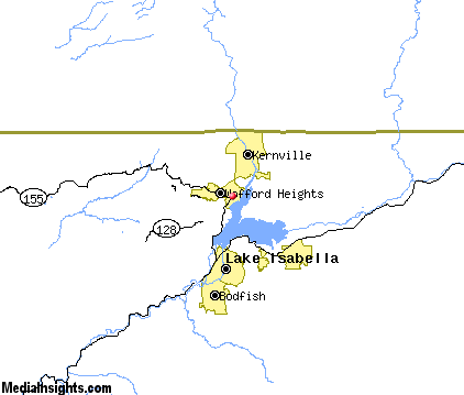
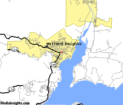
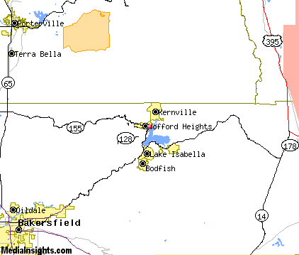
Wofford-Heights
is a small community of approximately 2200 located in Kern County, right alongside Lake Isabella in the high desert region of the southern Sierra Nevada Mountains. The city is spread out along the foot of the steep hillsides, against a backdrop of pine forest. It's near the Sequoia National Forest, and so makes a good base camp for anyone exploring the area. Lake Isabella and the Kern River are known for their outdoor recreational activities, including swimming, boating and fishing, rafting and kayaking. Non-lake activities include hiking and biking, golf, horseback riding and camping. The nearby town of Kernville has a quaint western flair, and offers many antique shops and specialty shops, restaurants, a wildlife preserve and museum. The Kernville Whiskey Flat Days is an annual event that continues for four days when the whole town returns to the days of the wild, wild west. Other options for fun in the Wofford Heights area include visiting the Silver City ghost town, exploring the back roads and small towns of French Gulch, Pioneer Point, Paradise Cove and Hungry Gulch. Alta Sierra is another small community located on the hills behind Wofford Heights that includes a shady pine forest and secluded campgrounds.

|
Wofford Heights Vacation Rentals
|

|
|
|
|
|
Wofford Heights Hotels and Resorts
|
|
|
| | | Hotels & Motels |
| Western Motel | | Kernville, CA | 3.7 mi. | (760) 376-3222 | | Kernville Inn | 11042 Kernville Rd | Kernville, CA | 3.8 mi. | (760) 376-3733 | | The Whispering Pines Lodge | 13745 Sierra Way | Kernville, CA | 4.4 mi. | (760) 376-3733 | | Rio Bravo Resort | 11200 Lake Ming Rd | Bakersfield, CA | 29.9 mi. | (661) 872-5000 |

|
Wofford Heights Weather & Climate
|

|
|
|
The high desert/foothills region located northeast of Bakersfield is part of the Sequoia National Forest. Elevations range from 1,000 feet around the foothills to peaks over 12,000 feet in the rugged backcountry. Therefore, temperature varies by elevation and conditions can change quickly and drastically depending on where you are. Generally, the foothills are characterized by hot, dry summers and wet, cool winters. Most precipitation occurs November through March in the form of rain in the lower elevations and snow in the higher elevations. Some higher mountains roads close for a while due to snow, others may be icy. During the winter, low-hanging clouds often drift in from the west, hanging around for several days at a time. Rain in the summer is rare, and wildfire is almost always a threat.
|
| Month |
High Temp |
Low Temp |
Rainfall |
Ocean Temp |
| January |
59°F |
31°F |
2.67 in. |
- |
| February |
62°F |
34°F |
2.41 in. |
- |
| March |
65°F |
37°F |
1.80 in. |
- |
| April |
71°F |
41°F |
0.48 in. |
- |
| May |
80°F |
48°F |
0.23 in. |
- |
| June |
89°F |
56°F |
0.03 in. |
- |
| July |
96°F |
62°F |
0.06 in. |
- |
| August |
96°F |
61°F |
0.09 in. |
- |
| September |
89°F |
55°F |
0.30 in. |
- |
| October |
79°F |
45°F |
0.28 in. |
- |
| November |
66°F |
35°F |
0.82 in. |
- |
| December |
60°F |
30°F |
1.55 in. |
- |

|
Wofford Heights Map & Transportation
|
|
|
 |
|
|
| Click each thumbnail image to enlarge. |
 |
|
 |
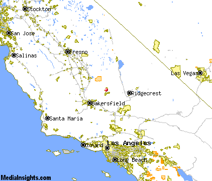 |
The closest airports in the area are the Inyokern airport (IYK) located about 35 miles east of Wofford Heights in Inyokern, California, Meadows Field (BFL) located approximately 38 miles west of Wofford Heights in Bakersfield, California, the Mojave airport (MHV) located roughly 47 miles south of Wofford Heights in Mojave, California, and finally the General Wm J Fox Airfield (WJF) located around 68 miles south of Wofford Heights in Lancaster, California.
|
|
Wofford Heights Attractions
|

|
|
| | | Amusement and Theme Parks |
| Six Flags Magic Mountain | Valencia | CA | 87.7 mi. | |
| | | Water Parks |
| Six Flags Hurricane Harbor | Valencia | CA | 87.7 mi. | | | Six Flags Hurricane Harbor | Santa Clarita | CA | 91.0 mi. | | | The Island Waterpark and Family Fun Village | Fresno | CA | 102.7 mi. | | | Wild Water Adventures | Clovis | CA | 103.9 mi. | | | Raging Waters | San Dimas | CA | 116.5 mi. | |
| | | Golf Courses |
| Kern Valley Golf Course | Kernville | CA | 3.1 mi. | | | Kern River Golf Course | Bakersfield | CA | 29.1 mi. | |
| | | Ski Areas |
| Ski Sunrise | Wrightwood | CA | 104.0 mi. | |
| | | State Parks |
| Kern River State Park | | CA | 31.0 mi. | |
| | | Museums |
| Kern County Museum | Bakersfield | CA | 39.1 mi. | (History) |
| | | Zoos and Aquariums |
| Chaffee Zoological Gardens | Fresno | CA | 102.7 mi. | | | Santa Barbara Zoological Gardens | Santa Barbara | CA | 113.3 mi. | | | Los Angeles Zoo | Los Angeles | CA | 115.0 mi. | |
Notice a problem with the information on this page? Please notify us.
|
Disclaimer: We recommend you conduct your own research regarding all accomodations and attractions found on this website. The distances shown on this website are straight-line distances as the crow flies. The road distance may be considerably longer. You assume all liability for use of any information found on this website. No information is confirmed or warranted in any way. By using our services you agree to the terms and conditions of this disclaimer.
|
| We are the #1 site for your California Vacation presenting California vacation rentals, hotels, weather and map for each city. |
California Vacation and Hawaiian Vacation are publications and trademarks of Media Insights, Inc.
©1997-2025 All Rights Reserved.
|
|