 |
Weed
lies on the western slopes of Mount Shasta, north of Redding along Interstate 5 near Lake Shastina and Grass Lake. Surrounded by national forests, high desert plains and volcanic formations makes the town of Weed not only a very scenic place to visit, but one of great geological interest, as well. From Weed there is easy access to a range of outdoor recreational activities. The Living Memorial Sculpture Garden is located a short drive up Highway 97, and nearby Lake Shastina offers swimming, water skiing, wind surfing, boating, and other water sports. An 18-hole Robert Trent Jones professional golf course and a 9-hole executive course are also at Lake Shastina. Backpackers love the area where miles of secluded trails are found winding through the pristine wilderness areas. Experienced hikers attempt the ascent of the 14,162-foot Mount Shasta, but others prefer the easier walk up 6,344-foot Black Butte, or the popular Pacific Crest Trail or the trails at Castle Crags State Park. In wintertime, Weed is near downhill skiing, a snowmobile park and cross country skiing. The town of Weed is just fifty miles from the Oregon State border, and its location at the intersection of Interstate 5 and Highway 97 marks the beginning of the Alaskan Highway.

|
Weed Vacation Rentals
|

|
|
|
|
|
Weed Hotels and Resorts
|
|
|
| | | Hotels & Motels |
| Comfort Inn | 1844 Shastina Dr | Weed, CA | | (530) 938-1982 | | Holiday Inn Express | 1830 Black Buute Dr | Weed, CA | | (530) 938-1308 | | Motel 6 | 466 N Weed Blvd | Weed, CA | | (530) 938-4101 | | Sis-q-inn Motel | 1825 Shastina Dr | Weed, CA | | (530) 938-4194 | | Mount Shasta Resort | 1000 Siskiyou LK Blvd | Mount Shasta City, CA | 8.2 mi. | (530) 926-3030 | | Mccloud Hotel | | Mccloud, CA | 17.2 mi. | (530) 964-2822 | | Amerihost Inn | 148 Moonlit Oaks Ave | Yreka, CA | 23.7 mi. | (530) 841-1300 | | Motel 6 #286 | 17855 Main St | Yreka, CA | 24.2 mi. | (530) 842-4111 | | Rodeway Inn | 1235 S Main St | Yreka, CA | 24.4 mi. | (530) 842-4412 | | Thunderbird Lodge | 526 S Main St | Yreka, CA | 24.8 mi. | (530) 842-4404 | | Comfort Inn | 1804 B Fort Jones Rd | Yreka, CA | 25.1 mi. | (530) 842-1612 | | Klamath Motor Lodge | 1111 So Main St | Yreka, CA | 25.1 mi. | (530) 842-2751 | | Rodeway Inn | 526 So Main St | Yreka, CA | 25.1 mi. | (530) 842-4404 | | Super 8 Motel | 136 Montague Rd | Yreka, CA | 25.4 mi. | (530) 842-5781 |

|
Weed Weather & Climate
|

|
|
|
The Mt. Shasta/Mt. Lassen region has a climate that varies greatly depending on the elevation. Generally, the area experiences a distinct winter, spring, summer and fall. The seasons are somewhat influenced by the Pacific Ocean. It always snows in the area, and winter temperatures can become quite cold. Usually, however, the snow melts quickly at lower elevations, with daytime highs in the mid 20s to mid 30s range. In summer, temperatures can reach 100 degrees, but that is rare. Highs are normally in the 75 to 85 degree range with cool nights. Most precipitation is received October through March. On the mountain summits, snow falls every month of the year, and even in the driest summers, glaciers remain on the north slope and large snow packs are visible from every viewpoint. On Mt. Shasta, the exposure to storms from the Pacific, plus its elevation, results in high winds and heavy snow accumulations.
|
| Month |
High Temp |
Low Temp |
Rainfall |
Ocean Temp |
| January |
43°F |
23°F |
3.68 in. |
- |
| February |
49°F |
27°F |
3.30 in. |
- |
| March |
53°F |
29°F |
3.54 in. |
- |
| April |
59°F |
33°F |
1.88 in. |
- |
| May |
68°F |
37°F |
1.36 in. |
- |
| June |
76°F |
44°F |
0.82 in. |
- |
| July |
84°F |
48°F |
0.32 in. |
- |
| August |
84°F |
47°F |
0.42 in. |
- |
| September |
77°F |
41°F |
0.49 in. |
- |
| October |
66°F |
34°F |
1.36 in. |
- |
| November |
50°F |
28°F |
3.11 in. |
- |
| December |
43°F |
24°F |
3.36 in. |
- |

|
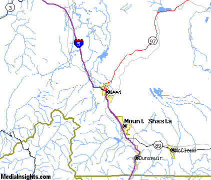
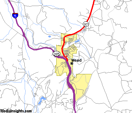
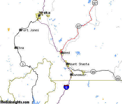
Weed Map & Transportation
|

|
|
 |
|
|
| Click each thumbnail image to enlarge. |
 |
|
 |
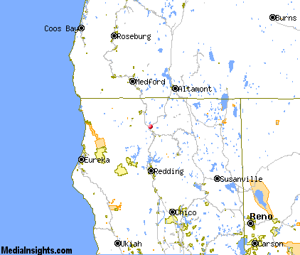 |
The closest airports in the area are the Siskiyou County airport (SIY) located about 25 miles north of Weed in Montague, California, the Klamath Falls airport (LMT) located approximately 60 miles northeast of Weed in Klamath Falls, Oregon, the Redding Municipal airport (RDD) located roughly 63 miles south of Weed in Redding, California, and finally the Rogue Valley International Medford airport (MFR) located around 70 miles northwest of Weed in Medford, Oregon.
|

|
Weed Attractions
|

|
|
| | | Water Parks |
| Waterworks Park | Redding | CA | 57.8 mi. | |
| | | Golf Courses |
| Weed Golf Club | Weed | CA | | | | McCloud Golf Club | McCloud | CA | 18.1 mi. | | | Shasta Valley Golf Club | Montague | CA | 21.7 mi. | |
| | | Ski Areas |
| Mount Ashland | Ashland | OR | 55.9 mi. | | | Mount Shasta Ski Park | Shasta | CA | 57.2 mi. | |
| | | State Parks |
| Castle Crags State Park | | CA | 17.6 mi. | |
| | | Museums |
| Herb Lane Museum | Redding | CA | 57.8 mi. | (Art) | | Redding Museum of Art and History | Redding | CA | 57.8 mi. | (Art) |
| | | Zoos and Aquariums |
| Sequoia Park Zoo | Eureka | CA | 102.0 mi. | |
Notice a problem with the information on this page? Please notify us.
|
Disclaimer: We recommend you conduct your own research regarding all accomodations and attractions found on this website. The distances shown on this website are straight-line distances as the crow flies. The road distance may be considerably longer. You assume all liability for use of any information found on this website. No information is confirmed or warranted in any way. By using our services you agree to the terms and conditions of this disclaimer.
|
| We are the #1 site for your California Vacation presenting California vacation rentals, hotels, weather and map for each city. |
California Vacation and Hawaiian Vacation are publications and trademarks of Media Insights, Inc.
©1997-2024 All Rights Reserved.
|
|